Friday, July 30, 2010

Rains begin due to the low pressure in India


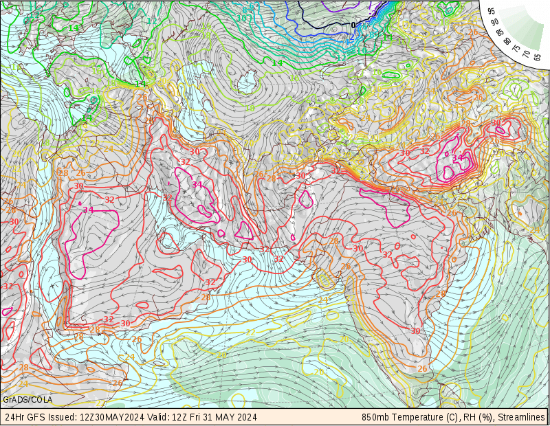
ABOVE- TOP IMAGE IS THE GFS 850MB VALID TILL 12Z,SATURDAY.. YOU CAN NOTICE THE ANTI CIRCULAR SPIN IS THE LOW PRESSURE
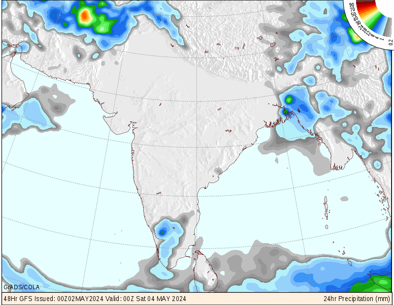
BOTTOM IMAGE IS OF 12PM,SAT-12PM SUN.. YOU CAN NOTICE HOW SUDDEN MOISTURE INCREASE OR INCURSION WILL HAPPEN DUE TO LOW PRESSURE DISAPPEARING


METD WEATHER,
Akshay Deoras,
Severe Weather Forecaster,

Widespread rainfall has been reported across Northern Maharashtra and parts of Central MP due to the presence of a well marked low pressure area resting over East Madhya Pradesh.
As a result of the first day in interior of India, this low pressure couldn't pull enough moisture resulting in less rains and I bet less rain rate over Northern Maharashtra and MP
Pachmarhi, MP received rainfall accumulating to 40mm which infact lies close to the featured low.
As considered for Akola,MH rainfall reported is near 30mm with a poor show of 12mm in Nagpur as recorded at 10PM

Rainfall amounts and rain rate will surely be on a rise on Saturday as the low pressure is expected to move SW from the current position and with some very rich moisture contents being seen in the 850mb offshore Western coast, this low will significantly pull the moisture thereby increasing the quantum and rain rate..
Depending upon the calculated forecast, I BET for some heavy rains in Nagpur and Northern Maharashtra also in central maharashtra.

5 DAY FORECAST-
NAGPUR-
RAINS WILL BE ON INCREASE ON SATURDAY IN NAGPUR
OVERNIGHT SLIGHT RAINS FROM FRIDAY WILL CONTINUE SATURDAY WITH SOME INCREASE IN RATE BY AFTERNOON AND EVENING PERIOD....
RAINS WILL BE ON A DECREASE FROM MONDAY

NORTHERN MAHARASHTRA TO CENTRAL MADHYA PRADESH
HEAVY RAINFALL TO CONTINUE

VERY HEAVY RAINS POSSIBLE THIS WEEKEND IN NAGPUR AND CENTRAL INDIA

WITH THE SURFACE LOW ORGANIZING OVER CENTRAL INDIA WITH THE CENTRAL PRESSURE OF 998MB ONLY... SOME GOOD RAINFALL IS EXPECTED IN NAGPUR AND OTHER PARTS OF NORTHERN MAHARASHTRA

THE PRESSURE IS NOT THAT STRONG AS WAS EXPECTED SO ONLY IF IT DEEPENS MORE, HEAVY RAINFALL WILL OCCUR...

FRIDAY NIGHT- NAGPUR CITY WILL WITNESS STRONG THUNDERSTORMS WITH LIGHTNING ENOUGH TO FORCE TO REMOVE ELECTRIC CONNECTIONS FOR SAFETY
WHILE ITS ALREADY RAINING HEAVILY IN CENTRAL MAHARASHTRA
SATURDAY THE NGP CITY WILL ALSO WITNESS GOOD RAINFALL IF LOW REMAINS STRONG.. I WILL UPDATE ON IT LATER THIS NIGHT AS SOON AS THE NEW MODEL RUNS COME

Thursday, July 29, 2010

Low pressure forms on Andhra Pradesh coast


METD WEATHER,
Akshay Deoras,
Severe Weather Forecaster

The most anticipated Low pressure finally formed in the given 24hr range!! Though this low pressure is very deep,I can say deeper than expected due to formation over the coast which had better atmospheric conditions than what I previously explained.. The location is shifted and the low having a surprising minimal pressure of 994mb centers AP coast

This low pressure is expected to deepen slightly more
As a result, Entire maharashtra particularly northern parts will get good rainfall

I will make a detail update tomorrow

Wednesday, July 28, 2010

A low pressure area will form in the BOB in next 24hrs


IMAGE-
1] UPPER AIR DIVERGENCE OF UAD IN THE BAY OF BENGAL. THE LOW PRESSURE TO FORM SLIGHTLY TO SW OF MAX. UAD. SO THIS STORM MIGHT NOT RELEASE SUFFICIENT LATENT HEAT FOR STRENGTHNING
BOTTOM-
THE LOW LEVEL CONVERGENCE OF LLC IN BOB


METD WEATHER,
Akshay Deoras
Extreme Weather Forecaster,

A widespread unorganized area of convection has formed offshore Karnataka as being depicted by Cloud top temperatures of -60C and the GFS weather models. Since the area is a widespread due to absence of development of a surface low to organize convection, a solid Vorticity is developing around this convection area and given the 15kt lower convergence and organised 20kt upper air divergence feature, this widespread convection will soon organize to an organised area having a LLC or Low level circulation embeded in it in the next 24hrs...

With an expected North-Northwestward propogation, this surface low is not expected to get converted to a significant depression having a central pressure of 995mb or less. The 1000mb Surface pressure models are indicating this feature to have a central pressure of 998mb in next 24hrs but with the northerly movement it might not deepen to a 995mb depression as had happened early this week over central India.

Naturally, this surface low also is expected to help the focus and intensity of SW monsoon winds towards central India and also to pump moisture on the way.. The forecasted path for this low is a path over Central India reaching Central India by the coming Monday,near 2nd August.
As a result, Central India will get good rains by this weekend marking an INCREASE IN RATE of rainfall also..

The intensity of this Surface low or I w'd say a short depression is likely to get affected by the persisting wind shears ranging form 20kt to as max as 40kt just North of the banding feature of this depression. So that will be a short intensified but long lived depression

WEATHER FORECASTS FOR NAGPUR
VALID FOR NEXT 5 days

With the absence of good low level moisture, NGP will receive just a spell of slight showers everyday from Wednesday mostly during afternoon period
Increase in rainfall activity by the end of this weekend

FOR CENTRAL INDIA
More or less similar weather upto this weekend but increase in rainfall at this weekend

Monday, July 26, 2010

Surface Low pressure sweeps away! New might form soon

METD WEATHER,
Akshay Deoras
Extreme Weather Forecaster

The 48hr toll- From 00z Sunday till Monday
Madhya Pradesh
Damoh-25.4cm
Jabalpur-16cm

Eastern Maharashtra-
Wardha 65mm
Amravti-4.8
Gondia-4.7
Nagpur- 4.2mm** To be verified

FORECAST FOR NAGPUR OF TUESDAY AND WED
TUE-- MOSTLY CLOUDY AND COOL WITH WARMER AFTERNOON PERIOD
CHANCE OF RAINS DURING THE DAY IS VERY LESS WITH A SPELL OF SLIGHT RAINS TOWARDS NIGHT
WED- WARMER DAY THAN TUE AND NO RAIN

FORECAST FOR EASTERN MAHARASHTRA
DECREASE IN RAINS AND WARMER DAYS
FOR NORTH INDIA-
THERE WILL BE RAINS ON TUESDAY IN NEW DELHI,PUNJAB,HARYANA JK ETC

With the surface low centered over Northern Gujarat as being indicated by the GFS models of 12z,26th July, Central India including Nagpur city has got good amount of rains in the past 48hrs as were expected. The low pressure is expected to travel across Arabian into Gulf countries

With absolutely no significant surface low pressure is expected to build in bay of bengal in the the next few days, dry air is expected to move from SE of India towards NW mainly to settle across South Central India first and then in central Maharashtra,Madhya Pradesh causing a dry air at the crucial 850mb and mid atmospheric levels.This relatively dry air at lower levels will restrict the rainfall in Central and Eastern Maharashtra and also in the South Central India in the coming 2-3 days resulting in warm day with surface moisture or humidity dominant...
On 28th July, GFS is indicating another low pressure area formation offshore Tamil Nadu which is expected to have a 1000mb initial pressure and move West-Northwest wards causing some rains in the same south Central India and parts like Nagpur city
Although this low pressure is not expected to create a miracle which the present did by pumping moisture over Central India and causing good rains, but will be a good for rains

I bet for the decrease in rains till next 3 days due to absence of moisture in Maharashtra but the coasts western part will be getting rains


Sunday, July 25, 2010

Good rains reported from Central India after that surface low swept across

A very good rainfall has been measured all across central India with chief amounts in Gadchiroli,Vidarbha apx 131.2mm and 100.2mm in Jabalpur.Where as the regional IMD center recorded near 23mm rains, rains recorded at METD WEATHER,HQ were apx 38mm which has added a good score to July month's lists which is on a 60% deficient for Nagpur.Four gates each of Pujaritola and Kalisarar dams were opened. Uncleaned drains led to water logging in several parts of the city.

Saturday, July 24, 2010

Some rains expected in Morning hours in Nagpur

ABOVE- JUST EAST OF MAHARASHTRA STATE THOSE CIRCULAR CLOUDS ARE THE LOW PRESSURE AREA CLOUDS... SINCE TRACK IS WESWARDS, SOME RAINS FOR NAGPUR ON THE WAY AND ALSO FOR NORTHERN MAHARASHTRA
METD WEATHER,
Akshay Deoras,
Extreme Weather Forecaster
** LOW PRESSURE AREA IS EXPECTED TO MOVE ACROSS VIDARBHA AND OTHER NORTHERN DISTRICTS OF MAHARASHTRA
** MORE HEAVY TO MODERATE RAINS POSSIBLE ON SOUTHERN SIDE OF NAGPUR
** NAGPUR CITY WILL RECEIVE LIGHT SHOWERS AND MODERATE AT TIMES DURING EARLY MORNING

With the West-North westward track of the newly formed low pressure zone in Bay of bengal which is currently resting near Raipur causing a 14mm rainfall as against a giant rainfall depicted by the GFS, some rains are being expected in the city in morning hours.
The Low pressure which is organizing convective clouds of -60C cloud tops to the East of maharashtra is likely to trigger rains as its precipitable core arrives over mainland.

With the last low pressure which had arrived and swept across city causing absolutely NO rains but heavy rains near by, this system is expected to do the same thing and will be a more problem to rural areas instead of Nagpur city. The reason for such a chaotic relation between atmospheric conditions as against the forecasted one seems to be a dominant international aspects like a Upsurge of positive IOD from the negative phase and less SW monsoon winds flow.
I bet the forecast models will have a better performance in the peak August and September when La Nina and Positive IOD will be sufficient to cause active monsoon

Forecast for 25th july 2010,Sunday
With the low pressure tracking West-northwest wards,GFS 12z indicating this convection will reach the peak of maximization of low pressure by the midnight of 24th and move with the moving winds towards Vidarbha and other Northern districts of Maharashtra causing light to moderate rains... At few ISOLATED places the rains will be very heavy and likely cause problems such as water logging

For Nagpur city,
Light rains all the way with one or two spell of slight moderate rains towards early morning is expected.Overall cloudy condition with a cool day. Less chance of rains after AFTERNOON
The rain rate is dependent on amount of moisture associated with this low pressure and also its intensity but considering its performance in eastern states, I don't expect severe rains as being depicted by GFS

Forecast for Monday,26th July
No such significant weather

Wednesday, July 21, 2010

Chanthu strengthens to CAT 1

TYPHOON CHANTHU HAS STRENGTHENED TO CAT.1
LANDFALL OF CHANTHU IS HAPPENING NOW AS BEING DEPICTED BY THE SATELLITE IMAGERY. LANDFALL IS HAPPENING TO THE SOUTH OF YULIN AND NORTH OF ZHANJIANG CHINA

Its really surprising to see Chanthu a cat.1 typhoon as the last models were indicating no such conditions will built to cause Chanthu to grow to a CAT 1

As of 00UTC,22ND JULY
CHANTHU IS A CAT.1 TYPHOON WITH WINDS OVER 70KT
20.7N,114.1E


TS Chanthu less likely to become a Cat.1.LANDFALL ON THURSDAY

ABOVE- THE YELLOW CIRCLE AROUND CHANTHU IS THE UPPER AIR DIVERGENCE PLOT AND THE BLUE CIRCLE IS THE LOW LEVEL CONVERGENCE.. THE PATH AS PER GFS IS SHOWN ABOVE

METD WEATHER,
Akshay Deoras,
Extreme Weather Forecaster

** TROPICAL STORM CHANTHU WILL ORGANIZE A LITTLE BUT WILL NOT BECOME A CAT. 1 IN NEXT 12HRS
** CHANTHU HAS NO THREAT TO HONG KONG CITY
** CHANTHU WILL MAKE A LANDFALL ON THURSDAY EVENING TO NIGHT HOURS(LT) AT ZHANJIANG,CHINA WHICH IS IN BETWEEN YULIN AND HAIKOU
** EXPECTED LANDFALL SPEED WILL BE 55KT,101KM/HR
** TIMINGS OF LANDFALL WILL BE POSTED ON THURSDAY POSTS


In the previous post, I had mentioned that Chanthu was more likely to become a Cat. 1 Typhoon on Thu morning but from the present atmospheric conditions, I can say that its less likely to become a Cat. 1
A surprising low shear had developed near the Center of Tropical storm of 10kt which caused it to get slightly unorganized and as its now very close to landfall perhaps it can't regain the lost distance and time

Forecasts as per 15Z UTC,21st July FOR MODELS
Chanthu lies at 19.2N,112.4E with winds recorded of 55kt. No wind shear has developed around it to weaken it. (AS PER 12Z)
5kt Low level convergence exists near the center of tropical storm
5Kt upper air divergence persists near the center of the storm
So CHANTHU will organize a little to reach winds upto 60kt

As per ADT models,17Z Chanthu had 985.3mb central pressure
AS per AMSU at 10z , Chanthu had pressure of 983mb and wind of 64kt

12HR FORECAST
CHANTHU WILL ORGANIZE IN SMALL SCALE AND CAN REACH WINDS UPTO 60KT
CHANTHU IS HEADING TO LANDFALL


Analysis of Strong Rainfall anomaly in India in 2010 Monsoon season

In local aspects of temperature, pressure and moisture, I don't find any snag thats preventing rainfall from not happening in the required quantity. The situation similar in appearance to the present was in late june- july period when the SW monsoon winds were not directed towards the main land as Phet had diverted the strong flow though some moisture was pumping in due to surface lows over Rajasthan and North central India. Then a organised low in BOB which swept across central India reaching Saurashtra in few days regulated the monsoon winds....

I have been using other models such as the Indian Ocean Dipole, ENSO appearance and the most important movement of MJO
I think you must be knowing the significance of Indian Ocean Dipole or Dipole mode index DMI in Summer Monsoon season or SW monsoon season.. The concept of IOD is similar to that of El~Nino and La Nina but IOD happens in Indian ocean only
A strong negative DMI means comparitively warm waters are present near Indonesia then near West Indian Ocean causing greater than avg rains in Indonesia and lesser than avg rains in India. 
There was a strong anomaly or Negative DMI in June reaching upto -0.8C.... Since it was an el nino year, less rains were expected by me but also I was and am hopeful to see an overall 65% normal rains or 35% deficient this time
The IOD is recovering and as per datas on early july it was 0.2C+
DMI now will rise causing good rains in India if there are no other barriers as such.. A significant negative IOD happened in 2009,2008 and Positive in 2007 which was the La nina year... 
Try to compare the annual rains for this year

(2)-- ENSO
El Nino Southern Oscillation has now transformed to a La Nina as being depicted by SST datas. 
This means the trade winds from East to west have now become strong and will likely push warmer water saturated near Indonesia to Western Indian Ocean thus rising the SST and helping for a Positive phase of IOD. 
During El Nino, trade winds weaken and local winds West-East push warm water to Indonesia causing Negative IOD

This year's La Nina coupled with developing positive IOD can result in better rains in August and some days of September as per my forecasts which I had made in May 2010.

(3) Madden Jullian Oscillation-MJO
MJO is a travelling rainfall anomaly across the Pacific and Indian oceans.Positive MJO helps in developing Severe Cyclones too. It was a +2 in June and it was a Cat.4 Phet which also was calculated by me in May
Right now, A good 2.0 cell looks travelling here. As of 16th July its near 140E and its a cool or negative MJO phase for Oceans around India so less rains.

(4) Monsoon trough shift
    Though I can't assure whether such thing has happened or not as I hadn't seen the positions of Jet streams over India after May end. The last time I had seen was before my travel to Ladakh to check the weather there.I think this year no significant Jet streams had reached India which c'd had prevented the trough shifting northwards.. IF no jets build, trough usually shifts north causing less rains in Kerala and central portions..

In all, I will expect a good rainfall in 2011 if La nina stays good and in August and some days in September 2010

--
Akshay Deoras,
akshaydeoras.blogspot.com
metdweather.blogspot.com
P- 94223-13055

Tuesday, July 20, 2010

Tropical Storm Chanthu gaining strength

ABOVE- THE IR IMAGE OF CHANTHU WITH THE GFS,CMC,UKM,NGP MODELS


METD WEATHER,
Akshay Deoras
Extreme Weather Forecaster

*TROPICAL STORM CHANTHU IS LIKELY TO INTENSIFY TO A CATEGORY.1 TYPHOON TOMORROW MORNING,local time BEFORE LANDFALL
* LANDFALL WILL BE WITH TROPICAL STORM STAGE

Located at 18.3N,113.0E and wind speed of 55kt at 00UTC,21st july, Tropical storm Chanthu finally managed to become a tropical storm from Tropical depression as it was facing a deficient Low level convergence and upper air divergence for a better outflow... I was expecting this feature to turn to a tropical storm late night of Monday as it finally got a better divergent feature..

Forecast models are indicating a very good chance of further intensification to a Cat.1 from tropical storm by tomorrow morning.. Right now, Chanthu is expected to move NW in a low level convergence field and upper divergence area... Warm SST coupled with absolutely no developing wind shear in the mid fields, Chanthu can become a Typhoon of winds over 65kt tomorrow morning

Landfall of Chanthu is expected to happen on Thursday evening to night hours..
The landfall of Chanthu will be surely away from Hong Kong city. It will be to the South of Yulin and north of Haikou as per the present model runs. Expected landfall strength will be near 55kt which will be a Tropical storm. Such thing will happen as a 20kt shear will be placed along with dry coastal air


Sunday, July 18, 2010

Another chapter in the 2010 Pacific Typhoon season


IMAGES-
TOP- THE 850MB VORTICITY OF 0900Z,18TH JULY
2] THE WIND SHEAR AND FORECASTED APPROACH OF TD-4

METD WEATHER,
Akshay Deoras
Extreme Weather Forecaster

With a noted three devastating landfall of Typhoon conson in Philippines, Hanian Is. and Vietnam and causing 78 reported deaths, another Tropical Storm is bound to form the western Pacific

Already designated as Tropical Depression 4 with winds of 30kt, this system has a well developing surface low in minute shear area above philippines. AS per the forecast models, this depression will enter the South China Sea just now at the time of forecast. With very less upper winds and a very good upper level divergence, warm air feeding in this storm from the sea will convert to a very nice latent heat outflow thus strengthening the system in a good lower level to mid level vorticity...
This tropical depression will have no barriers from now in the sea as no deep layer shear is expected to form within next 24hrs as the SHEAR TENDANCY to the NW of the Depression is decreasing...
This tropical depression will modify to a Tropical storm on Monday afternoon and will move towards NW pattern and expected to make a landfall on 21st June with the current tendancy to the EAST_NORTHEAST of HongKong city and mostlike HK will be affected by it

Saturday, July 17, 2010

Severe storms possible across Northern USA


METD WEATHER,
Akshay Deoras
Extreme Weather forecaster

A developing Shortwave trough digging in with strong upper level jets is expected to center over North Dakota with the surface low developing at the tri-front point. Severe weather is expected to pop up ahead of the cold front due to a deep moist airmass above the risk area.... Discrete supercells will form in the south-southwesterly low jets reaching 40kt at the SE of North Dakota pulling sufficient moisture from the gulf and making the firing possible.... Strong CAPE over 5000J/Kg with a very good shortwave in the 500mb will destabilise atmosphere making it favourable for severe thunderstorms which will be more linear fashion as I don't think discrete supercells will remain a long time...

Cold aloft and less PW as compared to other moderate risks for storms will lead to massive updrafts which will tend to be supportive for Severe hails mostly near Western Minnesota
Strong CAP is expected today at the target areas which tends for not breaking till Afternoon
I bet for some discrete supercells during initiation at SE ND,NE SD and western front of Minnesota capable of producing Hails and Tornadoes which then will merge to form a linear pattern. A linear organised storm moving along the front will increase the risk of high winds
This event seems to be fair for tornadoes as supercells will be more a linear based at later evening. Damaging hail risks is too high

SPC gets a 10% Tornado risk at West central Minesotta with a 5% extending some parts in Minnesota on the western front.
My tornado target is Fargo in North Dakota and few kilometers patch in South Central Minnesota

CONSON CHANGES THE PATH. NOW TO SLAM HAI PHONG

ABOVE- WUNDERGROUND GFS TRACK
METD WEATHER,
AKSHAY DEORAS

** CONSON HAS CHANGED THE PATH AND NOW WILL MAKE A LANDFALL AT HAI PHONG
** LANDFALL IN NEXT HOUR
** HEAVY RAINS, STRONG WINDS,STORM SURGE POSSIBLE.
** IT WILL THEN MOVE TO THAI NGYUGEN BY 0100HRS, 18TH JULY LOCAL TIME
TROPICAL STORM CONSON HAS CHANGED ITS PATH AND IS NOW DIRECTED TOWARDS MAKING A LANDFALL AT HAI PHONG,VIETNAM INSTEAD OF NAM DINH

THIS NEW PATH WILL RESULT IN A LANDFALL NEAR HAI PHONG IN 2HRS FROM NOW THUS GIVING A LANDFALL WINDOW OF

1830-1930HRS LOCAL TIME. EXPECTED WIND GUSTS WILL BE AROUND 52-53KT AND STORM SURGE UPTO 19FT AS PER JTWC
WIND GUSTS WILL BE NEAR 65KT.


Friday, July 16, 2010

TS Conson strikes Southern Hainan. Now heads towards Viet Nam

ABOVE- 1. THE TARGETED APPROACH OF CONSON
2.A CAR DAMAGED BY A TREE BRANCH AS CONSON SWEPT IN HAINAN IS.
img credit for img 2-- NEWS.CN

METD WEATHER
Akshay Deoras
Extreme Weather Forecaster

** TYPHOON CONSON HAS WEAKENED TO A TROPICAL STORM WITH WINDS OF 55KT.
** CONSON WILL MAKE A LANDFALL TODAY EVENING BY 6-7PM, VIETNAM TIME ICT NEAR NAM DINH,VIETNAM
** CONSON MADE A LANDFALL HAINAN ISLANDS
** RAINS WITH A FALL OF AIR PRESSURE NOW REPORTED FROM NAM DINH AIRPORT
** PEOPLE AROUND NAM DINH AND THE COASTAL AREAS SHOULD STAY ALERT FROM 1700HRS TILL LATE NIGHT AFTER THIS STORM PASSES
** STRONG WINDS AND STORM SURGE POSSIBLE

Typhoon Conson made a landfall at 7:50PM LT, 16th July 2010 near Sanya in the Hainan Is..
A lot of destruction has been reported at the island after winds peaking up to 125km/hr with heavy rains swept in the area. A lot of damage has been caused to life and property, thus destroying many houses and killing two people according to some report

After a making a landfall i.e a partial cut of from sea and a 30kt wind shear near the islands, Conson has now weakened to a tropical storm with the recorded wind speed of 55kt and at the location of 19N,107.4E as of 0000hrs, GMT.
The typhoon has unorganised a lot in the last few hours and despite of a warmer SST ahead is not expected to strengthen as I don't find any upper divergence which can help the storm to release the latent heat and strengthen.

Conson now heads towards North Viet Nam and landfall is due today late evening
With the GFS,CMC,UKM and NGP Computer models are indicating a landfall to the SE of Hanoi and mostly near Nam Dinh .
Strong winds,GALE and storm surges are possible with the landfall time


Typhoon Conson heading towards Viet Nam coast

METD WEATHER,
Akshay Deoras

TYPHOON CONSON IS NOW AT SW OF HALIAN IS.. AND AS CAT.1
IT WILL WEAKEN NOW TO A TS.

LANDFALL TOMORROW BETWEEN THAI NIMH AND NAM DINH BY 1800-1900HRS

Typhoon conson will weaken due to the 30kt Wind shear


METD WEATHER,
Akshay Deoras
Extreme Weather Forecaster,

THE CENTER OF THE TYPHOON IS JUST 75KM SE FROM SANYA,HAINAN ISLANDS.
THIS TYPHOON WILL MAKE A PARTIAL LANDFALL ACROSS SW COAST FO SANYA,HAINAN

Based on the new model runs from CIMSS, The 30kt wind shear is going to act as a "WALL" for the further strengthning of conson.
Conson was at 17.7N,110.1E at 13z utc. Conson is right now a Cat.1 typhoon with 75kt winds.

A minimum of 978mb pressure has been recorded at the surface stations

Conson will be weakning in next 12hrs. In next 12 hrs, the expected winds will be 65kt.
CONSON WILL MAKE A LANDFALL BETWEEN THAI BINH AND NAM DINH ON SATURDAY NIGHT BY 11.30Z AS A TROPICAL STORM WITH WINDS 65KT

BUT I AM STILL CONFIDENT THAT THE THE LANDFALL SPEED WILL BE NEARING TO 64-65KT AS ITS NOT A SIGNIFICANT WEAKENING

HEAVY RAINS WITH STRONG WINDS WILL BE HITING!


Typhoon Conson strengthens to Cat.1 advances to Vietnam

above- The forecast models via CIMSS for typhoon Conson

METD WEATHER,
Akshay Deoras

** TYPHOON CONSON STRENGTHENS TO CAT.1
** LANDFALL IS EXPECTED TO BE ON SATURDAY EVENING TO NIGHT HOURS
** METD WEATHER,MARK 5 ALERT FOR VIETNAM COAST
** LANDFALL EXPECTED WITH CAT.1 BETWEEN THAI HOI AND NAMH DINH BY LATE EVENING TO NIGHT HOURS
The well marked low pressure which turned to a tropical storm on July 11th and made a deadly landfall at quezon provience in Philippines and killed 23 people and many missing has now organised to a Cat.1 cyclone.
With the wind speed to a 75kt,gusts to 90kt. this typhoon organised as it moved in warmer waters and away from the 20kt wind shear late night yesterday. Typhoon right now is 16.9N,110.9E and has moved 270deg at 90kt.
Typhoon is heading towards Vietnam near the Hanoi coast.... Its still much far away..

THE NEW COMPUTER MODELS FOR METD WEATHER
We have started using a new brand of computer models which are very accurate for Cyclone forecasts via CIMSS
The current position of Typhoon is a position where it can easily maintain the strength.Its in a pool of warm sea water with no significant wind shear at place and 10kt divergent winds aloft
a 30kt, wind shear lies ahead at 13.7N,111.5E where conson will reach in next 15hrs, But the wind shear line doesn't seem to affect the intensity as its much in a limited area unlike the 20kt previous circular wind shear which had kept conson to a Tropical storm cat.
Also, a big pool of warmer water will be present ahead which will intensify consoon more but will be a Cat.1 only
As per forecast,80kt winds are expected in conson in next 24hrs.
With no wind shear and convergence ahead, Conson will maintain the strength

Conson will make a landfall at Saturday evening to night hours
Landfall is expected to be between Thai hoi and Nam Dinh coast..
Expected category for the landfall will be CAT.1 as I believe the strength will continue due to no obstruction till the landfall

Wednesday, July 14, 2010

Early morning rains in Nagpur on Thursday

I know its pretty late to send the email
Heavy rains are expected to strike nagpur on Thursday morning 
I will expect rains from 6Am which will continue till noon period if the surface low pressure approaches on time.
Heavy rains will hit in morning period and mostly the delay caused will be minimal
Carry umbrellas for morning walk

--
Akshay Deoras,
akshaydeoras.blogspot.com
metdweather.blogspot.com
P- 94223-13055

SPC upgrades risk to Moderate level In USA

METD WEATHER,
Akshay Deoras
Extreme Weather Forecaster

Based on new model runs,11z,14th July

As storms already have fired in CAP deficient area, forecast models are showing a big deal across Minnesota and parts of Wisconsin. 
Storms have already fired in SE North Dakota in the warm front and will brace in Minnesota and WI by post afternoon period
RUC models are indicating a very high level MCAPE will develope ranging to 9000J/Kg will develope at the IOWA-Minnesota border which will spread towards north later of the day. With the progressing warm  front, severe storms will move around with a linear fashion increasing the threat for HIGH WINDS AND HAILS
SPC HAS MENTIONED A 60% RISK OF 60KT AND GREATER WIND IN 25 MILES OF A POINT...

SHEARS WILL BE SUFFICIENT ENOUGH TO TRIGGER TORNADOES AND NOW I AM EXPECTING ATLEAST A DOZEN TORNADO

--
Akshay Deoras,
akshaydeoras.blogspot.com
metdweather.blogspot.com
P- 94223-13055

Tuesday, July 13, 2010

Severe Weather possible in Northern USA

METD WEATHER,
Akshay Deoras,
Extreme Weather Forecaster


A potentially severe weather will pop on Wednesday at the nose of the trough digging in from the west.. With the 300mb winds over 100kt in vicinity and 70kt in the 500mb levels, the South-Westerly flow will help severe weather to build in... With the 40-50kt LLJ, a lot of moisture will be pulled in in parts of Northern IOWA, Western Wisconsin and South-Eastern Minnesota leading to ample moisture at SFC and dewpoint upto 80F. Provided with a Weak CAP and strong CAPE 3000-5000J/Kg, the trough will get into a negative tilt and will fire severe thunderstorms in IOWA,WISCONSIN,and some parts of Minnesota.. With an excellent wind shear field in lower levels, rotations with mesocyclones in supercells is possible in the risk area. The PW precipitable value is indicating values upto 2" indicating Classic HP,high precipitation supercells possible....
An approaching cold and warm front from the west will be present over the risk area by 18z,wednesday and the tripoint lies just at the Minnesota and Wisconsin border by late evening to night hours. Severe storms will explode in afternoon to late evening hours as strong CAP will be inplace which will get less due to day time heating
I WILL NOT BE SURPRISED IF SPC UPGRADES THE SITUATION FROM SLIGHT TO MODERATE...
DAMAGING HAILS WITH AT LEAST HALF DOZEN TORNADOES POSSIBLE IN THE RISK AREA

My target area is Minneapolis 

--
Akshay Deoras,
akshaydeoras.blogspot.com
metdweather.blogspot.com
P- 94223-13055

Thursday, July 8, 2010

Winner of METD WEATHER's contest- "Predict the heavy rain day in Nagpur"

Recently, an online competition was organised by METD WEATHER which was open to all
The competition was related to weather predictions. People had to predict the dates on which heavy rains will lash the city of Nagpur in the month of July
I had received 5 entries out of which Mr. Pravin Nandedkar gave the date of 6th and 7th July while Mrs. Manisha Gotmare gave the date of 8th July

Surprisingly it rained very heavily on these 3 days and competition became tough
The terms and conditions of competition were as follows-

THER

E MUST BE RAINS ON THAT DAY.2] RAINFALL ACCUMULATION IN TOTAL MU

ST BE OVER 25MM..3] HEAVY RAINS MEANS VERY HEAVY RATE..4] SUCH RATE MUST BE WIT

NESSED ATLEAST FOR 1HR..5] DATE VALIDS FROM 00AM TO 11:59PM OF THE DAY.

6] ORDINARY SPELLS WILL NOT BE REGARDED. THIS IS THE CRITERIA WHICH WILL DECIDE WHO

IS THE WINNER

On 7th July it rained very heavily and accumulation was 65m
m.
But on 8th July the rain rate was much higher and rains recorde
d by 11:59 PM were 13mm.
However in the night time, rainfall colle
cted was 30mm

So there are two winners of the competition and I award them " Smart Weather Forecaster"

left- Mrs. Manisha Gotmare. the winner


Mr.Pravin Nandedkar
The winner


Monsoon arrived on 2nd July 2010

The SW monsoon had arrived on 2nd July 2010 and thus again I have scored a 100%
For the month of july, rains will be almost everyday sometimes less or more
From 1st July to 9th July, a total of 97.5mm rainfall has occured.
I will not email everyday regarding rains but you can find out about alerts from the blog or twitter or facebook
Today- Chance of light to moderate rains from post afternoon hours into night hours

--
Akshay Deoras,
akshaydeoras.blogspot.com
metdweather.blogspot.com
P- 94223-13055

Wednesday, July 7, 2010

Heavy rains disrupts life in India!


METD WEATHER,
Akshay Deoras,
Extreme Weather Forecaster

Heavy to very heavy rains have disrupted life of people in Northern India. It has rained very heavily in Punjab,Haryana and Himachal Pradesh throwing life out of gear due to flash floods causing a 5ft water logging in Ambala area.Flash floods in this areas have led extreme water accumulation in Ludhiana, Ambala,Kurukshetra,Karnal and other prominent stations on New Delhi- Jammu Tawi route enrouting ludhiana

Cancelled Trains:
  • Railway officials say these trains have been cancelled:
  • Amritsar-Delhi Shatabdi,
  • Amrtisar-Haridwar Janshatabdi, Amritsar-Delhi inter-city,
  • Bhiwani-Delhi-Kalka Ekta express, Mumbai-Amritsar Golden
  • Temple Express, Jammu-Rishikesh Hemkund Express, Himalayan
  • Queen, Haridwar-Bathinda-Ganganagar Express, Jammu Mail,
  • Jalandhar-New Delhi Inter-City Express, New Delhi-Kalka
  • Shatabdi Express, Kalka-Barmer Express, New Delhi-Amritsar
  • Shan-e -Punjab Express, New Delhi-Jammu Tawi special,
  • Amritsar-Dehradun Express, Chandigarh-Lucknow Express, New
  • Delhi-Una Himachal Express.

Due to heavy rains and a breach in Satluj-Yamuna link of 100ft in Gulabgarh village nearly hundreds of villages have been submerged under water. Road traffic on NH-1 is affected as roads were submerged in waters from near Nahar. So far water accumulations have meant The highest rainfall in ambala
Passengers were stranded at the airport,stations due to rains.
Ambala received 196.7 mm of rainfall, followed by 60.6 mm at Ludhiana, 59.2 mm at Nangal Dam, 14.8 mm at Bhiwani, 30 mm at Panchkula, 44 mm at Kurukshetra, 3 mm at Karnal and 11.2 mm at Patiala.
Now, rains are calming down and no significant rains to strike again in this region in next 48hrs. However it can rain moderately from Saturday night.
ON WEDNESDAY, NAGPUR CITY AND SURROUNDING AREAS ALSO WITNESSED VERY HEAVY RAINS.
AS PER THE DATA RECORDED FROM METD WEATHER,HQ. 65MM RAINS OCCURED FROM 12PM-6PM.


HIGH temperature expected today in North-East USA


METD WEATHER,
Akshay Deoras
Extreme Weather Forecaster,
Concerning- Heat Advisory in upper-east
HEAT WAVE ADVISORY IN EFFECT TILL 11PM EDT ALONG THE EASTERN TO NORTH-EASTERN STATES INCLUDING DISTRICT OF COLOMBIA,WASHINGTON,DC

This probably will be a memorable day for people living in Washington DC and surrounding areas as temperatures today are expected to hit apx 100F and Virtual temp. will be around 105F or 40C
A strong dominant high pressure off coast of Washington if 1016mb will be causing a very warm temperature. With absolutely no clouds building due to a very low Dewpoint and moistures, temperatures will soar to 100F. In the coming days, this heat wave i.e upper level disturbance will brace away allowing the developed cold front to strike and permitting some rains and thunderstorms and lowering the temperatures by solid few degrees
On Thursday and Friday, heat wave will not that be intensified but temperatures are most likely to be in 80-90F at maximum

SPC has issued a heat advisory in foll areas
DISTRICT OF COLUMBIA-WASHINGTON-FREDERICK MD-CARROLL-
NORTHERN BALTIMORE-HARFORD-MONTGOMERY-HOWARD-SOUTHERN BALTIMORE- 
PRINCE GEORGES-ANNE ARUNDEL-CHARLES-ST.
 MARYS-CALVERT-SHENANDOAH- FREDERICK VA-PAGE
-WARREN-CLARKE-NELSON-ALBEMARLE-GREENE-MADISON- 
RAPPAHANNOCK-LOUDOUN-ORANGE-CULPEPER-
 PRINCE WILLIAM/MANASSAS/MANASSAS PARK-FAIRFAX- 
ARLINGTON/FALLS CHURCH/ALEXANDRIA-STAFFORD-SPOTSYLVANIA-
 KING GEORGE-NORTHERN FAUQUIER-SOUTHERN FAUQUIER-MORGAN-BERKELEY-
 JEFFERSON- 
INCLUDING THE CITIES OF...WASHINGTON...HAGERSTOWN...FREDERICK..
. WESTMINSTER...GAITHERSBURG...COLUMBIA...BALTIMORE..
.ANNAPOLIS... WALDORF...ST MARYS CITY...WINCHESTER..
.FRONT ROYAL... CHARLOTTESVILLE...LEESBURG...CULPEPER...
MANASSAS... MANASSAS PARK...FAIRFAX...ALEXANDRIA...FALLS CHURCH..
. FREDERICKSBURG...WARRENTON...MARTINSBURG...CHARLES TOWN
RECORD BREAKING TEMPERATURES POSSIBLE

Sunday, July 4, 2010

SW Monsoon progresses towards North after arriving in Nagpur


METD WEATHER,
Akshay Deoras,
Extreme Weather Forecaster,

SW MONSOON arrived on 2nd July 2010 in Nagpur and METD WEATHER again scoring a 100% result consecutively for the second year. Though, rains have not been that strong in Nagpur they are very strong around Nagpur and in many surrounding districts. Due to a a Low pressure area which recently moved across Central India, Monsoon winds current regulated.
The GFS forecast are showing superb rains in Northern India which will be termed as Monsoon.
Heavy rains will grip parts of Punjab,Haryana and Chandigarh from Monday and at Delhi.
Very heavy rainfall is expected to hit Chandigarh and areas around it

New Delhi will witness few rains on monday. Chandigarh,ludhiana will receive a T.storm on mon,tue nights

Saturday, July 3, 2010

Heavy rains grips Mumbai city and also some parts of Gujarat

ABOVE-THE GFS,700MB VERTICAL VORTICITY AND PRECIPITATION MODEL SHOWING HEAVY RAINS IN SOUTHERN GUJARAT. THE ABOVE FORECAST IS OF SUNDAY,4TH JULY 2010

METD WEATHER,
Akshay Deoras,
Extreme Weather Forecaster

Extremely heavy rains gripped Mumbai city on Saturday and has disrupted the traffic and life of people. This is happening as the Low pressure from Bay of Ben
gal which recently centered over Maharashtra and Chattisgarh speedily went Westward and is now centered over Daman diu. This low pressure is extensively pulling moisture from the moisture rich Arabian Sea which is causing Very heavy rains in Mumbai,South-eastern Gujarat and areas of North of Mumbai.
GFS,00z has been showing more than a 100mm rains in Mumbai. As the mid and lower levels of atmosphere over mumbai and densely rich with moisture, heavy rains in few intervals are happening

Forecasts says that more rains will hit Mumbai city on Saturday and will be heavy by Saturday night, on Sunday, comparatively less rainfall in Mumbai and Western belt though can trigger some problems due to afternoon high tides
Rains will be very heavy on Southern Gujarat areas
like Rajkot,Baroda, Surat etc.

Meanwhile, In interior Maharashtra rains will be quite heavy on Sunday

BELOW- THE 850MB MAP SHOWING THAT LOW PRESSURE AREA IS CENTERED NEAR SURAT,GUJARAT. YOU CAN SEE HOW MOISTURE IS GETTING PULLED INWARDS AND FAVOURING THE MONSOON ADVANCEMENT

Thursday, July 1, 2010

Rainfall watch still continues for many areas in Maharashtra

It didn't rain in Nagpur on Thursday despite the weather models indicated! But Thursday proved to be very damaging for parts of Yavatmal, Bhandara, as flooding situations were seen with hailstorms at some places. I am still in darkness about the reason of NO RAINS in Nagpur despite a thunderstorm in Nagpur at midnight. 
Continuing, The Global Forecasting System's GFS models are still indicating heavy rainfall potentials in and around Nagpur
I will figure out- 

Mark II alert continues for Nagpur district, Amravati,Akola,Buldhana and Wardha,Chandrapur,Yavatmal district on the second day. Flooding potentials again today with floods already reported there.

FOR FRIDAY, RAINS SEEM TO BE THERE IN NAGPUR CITY DURING AFTERNOON AND ARE COMPARITIVELY LESS IN THESE AREAS AS COMPARED TO YESTERDAY. BUT IF THE GFS,850MB MAINTAINS STRENGTH, THEN IT CAN RAIN VERY HEAVILY WITH THUNDERSTORMS IN NAGPUR CITY, AND THESES AREAS CAUSING FLOODING PROBLEMS AND HAILSTORMS IF ENOUGH CAPE BUILDS UP
SUNDAY- RAINS WILL BE IN ALL LESS AND MONDAY CAN WITNESS PARTLY CLEAR WEATHER


I WILL STILL URGE EVERYONE TO FOLLOW THE INSTRUCTIONS AS SOME OF MY SENIOR FRIENDS WERE STUCK FOR SOME HOURS NEAR YAVATMAL YESTERDAY. IF ANYONE WANTS TO TRAVEL TO THESE AREAS TOMORROW, YOU MUST TRAVEL WITH ALL NECESSARY THINGS FOR ALL TYPES OF SITUATIONS. 
METD WEATHER HAD WARNED YESTERDAY ALSO IN THESE AREAS AND RESULT WAS OUT... MANY KILLED. 
MARK II ALERT CONTINUES TILL SUNDAY EARLY PERIOD.
-- 
Akshay Deoras,
akshaydeoras.blogspot.com
metdweather.blogspot.com
P- 94223-13055

RAINFALL TO HIT 8:30-9:30PM TONIGHT

I AM EXTREMELY SORRY TO HAVE MISCALCULATED THE TIMINGS OF RAINFALLBY A SOLID 3HR GAP
THE LOW PRESSURE ALSO HAS SLOWED DOWN BUT PROBABILITY OF RAINS STANDS A 100%....
NOW RAINS WILL ARRIVE IN 8:30-9:30PM TIMESLOT WITH A THUNDERSTORM. THEY WILL BE VERY HEAVY BY MIDNIGHT AND MARK ARRIVAL OF THE MONSOON...
NEED TO REMOVE ELECTRIC CONNECTIONS AT THAT TIME

--
Akshay Deoras,
akshaydeoras.blogspot.com
metdweather.blogspot.com
P- 94223-13055