Thursday, April 28, 2011
Wednesday, April 27, 2011
HIGH RISK ACROSS GULF STATES! Very Very Strong Tornadoes likely


Akshay Deoras
Severe Weather Forecaster
Concerning- HIGH RISK OF SEVERE STORMS ACROSS A WIDE AREA IN GULF STATES
SPC AC 271255
DAY 1 CONVECTIVE OUTLOOK
NWS STORM PREDICTION CENTER NORMAN OK
0755 AM CDT WED APR 27 2011
VALID 271300Z - 281200Z
...THERE IS A HIGH RISK OF SVR TSTMS TODAY INTO EARLY TONIGHT FOR NE
MS...CENTRAL/NRN AL...NW GA...SE TN...
...THERE IS A MDT RISK OF SVR TSTMS SURROUNDING THE HIGH RISK...FROM
NRN/CENTRAL MS TO SRN AL...NW GA...MIDDLE/ERN TN...WRN SC...WRN
NC...WRN VA...AND ERN KY...
...THERE IS A SLGT RISK OF SVR TSTMS FROM THE N CENTRAL GULF COAST
TO THE OH VALLEY/APPALACHIANS AND NY...
--DANGEROUS TORNADO OUTBREAK IS EXPECTED FROM LATE MORNING INTO LATE
EVENING ACROSS THE TN VALLEY REGION--
------ STORM PREDICTION CENTER,NORMAN
As mentioned in the previous post, a Potentially dangerous severe weather outbreak is expected today in the gulf states
METD WEATHER Synopsis-
An intense mid level negative tilted trough shall swing over the gulf states causing an active atmosphere for severe storms to develop. With the mid level jets over 100kt and the amplifying and north eastward progressing surface cyclone, the persisting th
understorms shall migrate eastwards with more linear fashion ( Squall line) later today with the cold front.
Moisture again shall not be a problem as given by the upper 70F dewpoint due to intense Low Level jets of 60kt+ winds which w'd rapidly pull moisture from gulf of mexico
As all ingredients come together with presence of MLCAPE 2000-5000J/Kg storms shall modify into severe thunderstorms in Eastern AR,Northern and Central MS,Northern Alabama,Central Alabama and Western,Central Tennessee
Storms capable of producing large hails,strong winds shall be primary threat
Presence of Strong Wind Shears for rotations, strong supercells capable of producing STRONG AND LONG TRACK TORNADOES shall strike from Wednesday morning into night hours in Northern Mississippi,Western TN,Northern Alabama and NW Georgia with the SFC low migrating Northwards into Kentucky.
Thus it shall be a major day and likely tornadoes in a wide area as a result I am not issuing any Tornado target for the day
I w'd not be surprised to see many tornado reports and long track tornadoes
Main Threat-
North Eastern MS, ( For some early period)
Western TN,
Central TN, **- STRONG TORNADOES LIKELY around Nashville
Central AL,**
Western AL,**
South Eastern Kentucky,
NW GA,
NE MS **
** - Greatest Probability of Strong Tornadoes
Western Tennessee and Northern and North Western Mississippi,North Western and Northern Alabama are requested to track the severe weather
Supercells have exploded and are in a region of Wind Shears over 500m2 s2!
This shall be some primary strong threat and even stronger than the HIGH RISK
Supercells have exploded and are in a region of Wind Shears over 500m2 s2!
This shall be some primary strong threat and even stronger than the HIGH RISK
PEOPLE IN THE AREAS ARE REQUESTED TO FOLLOW THE WEATHER UPDATES AS THIS IS AN EPIC SITUATION
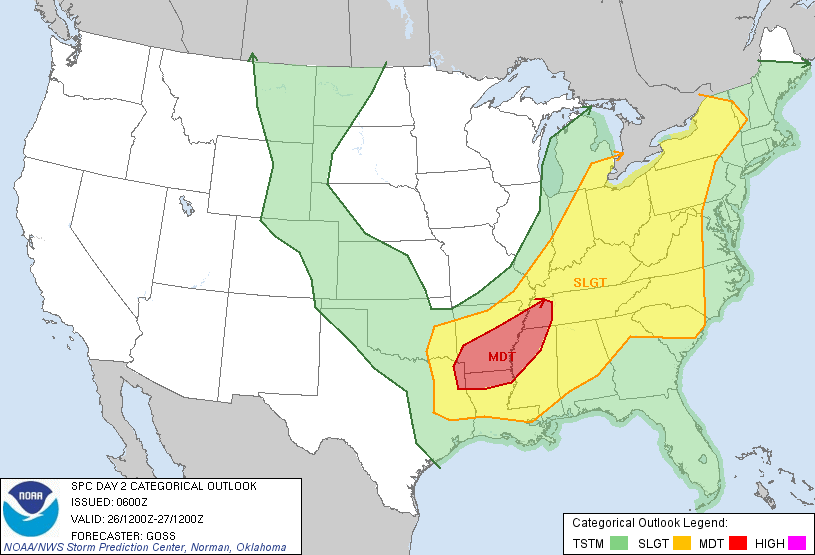
Tuesday, April 26, 2011
HIGH RISK OF SEVERE STORMS! Dangerous tornadoes likely!

Akshay Deoras
Severe Weather Forecaster
Concerning- HIGH RISK of Severe Storms !
VALID 261300Z - 271200Z
...THERE IS A HIGH RISK OF SVR TSTMS LATE THIS AFTERNOON INTO
TONIGHT FOR NE TX...FAR SE OK...EXTREME NW LA...AND THE SRN HALF OF
AR...
Synopsis-
The amplifying shortwave trough is expected to begin its Eastward movement from today with Jet streaks at its nose over 100kt jets at the 300mb and 60kt at 500mb is expected to bring very severe weather today/tonight in a wide area stretching from
NE Texas,Into Eastern South Eastern Oklahoma stretching into Arkansas,Northern LA,NW
 MS,WEST TN and the rest neighbouring states ( CENTRAL GULF STATES)
Potent strong Jet streaks and the associated developing surface cyclone in the warmsector having persistent moisture from yesterday's setup ( A major tornado outbreak in Arkansas with Emergency Declared and Long track tornadoes in Vilomina and Hot Spring) shall fire severe thunderstorms in the Steep Lapse rate,Strong Lifting and strong CAPE over 2000J/Kg around Dallas,TX after 1PM or so ( LT)
Storms developing in these areas shall modify into severe and supercells especially around North Central to North East Texas jumping in SE Oklahoma and SW- Central AR
The Ground HEL ( 0-1km) indicate favoring supercells with large and long track tornadoes in
 the NE Texas and SW Arkansas
HOWEVER, The Hodograph indicatelow level curvatures after evening which might indicate that Tornadoes would be likely after evening period.
There shall be some weakening in the shears for afternoon period however threat for strongovernight tornadoes shall build up as the shears start organizing!
However TORNADOES CAN BE EXPECTED in SE Oklahoma at afternoon period

Considering all the parameters, it looks like the greatest probability of tornado lies from Dallas to Little Rock,AR
My tornado targets -
1] East of Paris,TX 2] Around TEXARKANA
3] Around Camden,AR
Tornadoes then shall migrate northwards
Keep following
spc.noaa.gov for more details
Wednesday-
The shortwave trough shall surge through southern plains, with the 60kt LLJ,STRONG CAPE and favorable conditions, I shall not be surprised if Moderate Risk turns to High Risk
VALID 271200Z - 281200Z
...THERE IS A MDT RISK OF SVR TSTMS ACROSS A LARGE PORTION OF
KENTUCKY AND TENNESSEE...NORTHEAST AND EAST CENTRAL
MISSISSIPPI...THE NORTHERN HALF OF ALABAMA...AND NORTHWEST
GEORGIA... ON WEDNESDAY(27th Apr 2011)
My tornado targets -
1] East of Paris,TX
2] Around TEXARKANA
3] Around Camden,AR
Tornadoes then shall migrate northwards
Keep following
spc.noaa.gov for more details
Wednesday-
The shortwave trough shall surge through southern plains, with the 60kt LLJ,STRONG CAPE and favorable conditions, I shall not be surprised if Moderate Risk turns to High Risk
VALID 271200Z - 281200Z
...THERE IS A MDT RISK OF SVR TSTMS ACROSS A LARGE PORTION OF
KENTUCKY AND TENNESSEE...NORTHEAST AND EAST CENTRAL
MISSISSIPPI...THE NORTHERN HALF OF ALABAMA...AND NORTHWEST
GEORGIA... ON WEDNESDAY(27th Apr 2011)
Sunday, April 24, 2011
Round of Severe Weather on Monday,Tuesday,Wednesday


Akshay Deoras
Severe Weather Forecaster
There is a Moderate Risk of Severe Storms across Much of Arkansas and some areas in MO on Monday
The mid level shortwave trough currently digging in from pacific is expected to bring severe weather into the plains Monday as the embeded jet streaks at the nose of upper level jet
Favored by the eastward progression of the dryline and the SFC low in Western to Central Oklahoma, severe storms shall fire around Central OK in the perfectly unstable warm sector where CAPE values are over 2000J/Kg and LI over -7
Moisture shall not be a problem from this setup as SFC dewpoints are over 60F indicating nice moisture
As the storms brace eastwards into SW Ok and Western Arkansas, presence of a good wind shear shall support developments of supercells capable of producing large hails and few tornadoes.
Hodographs indicate less curvatures across SW Oklahoma so I w'd probably not think of this location for tornadoes
As the Low level jets intensity over 50kt in Arkansas and favored by steep lapse rate in evening hours, Threat for Tornadoes builds up.
What it seems right now, areas situated West and NW of Little Rock shall get to see some tornadoes at night time especially around Hot Spring,AR
People must watch out for this region.
Tue
Friday, April 22, 2011
Strongest Thunderstorm in 25 years hits Vidarbha!


Akshay Deoras
Severe Weather Forecaster
As forecasted and ALERTED by METD WEATHER,
A very strong thunderstorm hit Vidarbha on Thursday with very large hails,rains and winds with strong lightning!
Nagpur reported a rainfall in Evening hours ( 06PM) with appearance of Mammatus Clouds
There was a strong overnight thunderstorm and rainfall ( Friday morning) accumulating to 11mm as reported at METD WEATHER HQ
However,
Strong Thunderstorm hit many places excluding NGP
Despite Warned!
100s of people were injured including 3 seriously injured as roof collapses down.Crops costing over lakh rupees destroyed.
Hailstorm hit Kondhali,Katol,Narkhed,Parseoni,Ramtek
Hails of 2" in Diameter were reported in Kondhali!
Hailstorm began at 0430PM in these areas
100s of people were injured including 3 seriously injured as roof collapses down.Crops costing over lakh rupees destroyed.
Hailstorm hit Kondhali,Katol,Narkhed,Parseon
Hails of 2" in Diameter were reported in Kondhali!
Hailstorm began at 0430PM in these areas
Check the entire report in the image of the Daily Newspaper - The Hitavada dated Fri 22nd Apri 2011
Wednesday, April 20, 2011
Strong Thunderstorms,Heavy Rains possible in Central India on Thu-Fri
 REFERENCE MAP TO DESCRIBE THREAT LEVEL AS MENTIONED BELOW
METD WEATHER
Akshay Deoras
Severe Weather Forecaster
A round of severe weather can be expected in the Central India region from Thu-Fri ( 21 and 22nd Apr 2011)
For Thursday,21st Apr 2011


Severe storms are expected to fire at the nose of the southern extent of jet stream aloft as the surface low continues to intensify in the region with the MSLP as per Thai Meteorological Dept of 1002mb! As the surface low deepens, it shall pull moisture from the Southern Region and South Western Region along with the Low Level Jets of 24-32kt thus providing the moisture in the persistent unstable atmosphere
The GFS 12z runs indicates upto 1000J/Kg CAPE present over Central India while the same timed Skew T indicate upto 500J/Kg joules in AN UNCAPPED ENVIRONMENT
With enough instability to support convection, and INSANE LIFTING ( LIFTED INDEX UPTO -5!!), Severe thunderstorms capable of producing Heavy Rains,Lightning,Strong Winds,Sudden drop of temperature shall be very likely
The main concern is for the following areas
Nagpur and the 100km circle radius as shown on Doppler Images
Areas around Gondia where strong CAPE is present
Isolated areas NE of Seoni in Madhya Pradesh
West of Amravati
** All areas in 200km radius of Nagpur as the center
Threat-
Threat is for Rains,Strong Winds,Hails and strong lightning during late evening into night
---------------------------------------------------------------------------------------------------------------------
For Friday- 22nd Apr 2011

As more moisture is dumped on Friday, with comparitively less instability
threat shall continue for Heavy Rains
These areas include -
Nagpur,Central and Southern Madhya Pradesh and other areas 200km radius of Nagpur ( Excluding the areas beyond 50km west of Nagpur)
** Flash Flooding also possible in areas like Southern MP,Vidarbha many areas in the 100km circle of Nagpur
Preparation -
Keep yourselves dry using raincoats and umbrellas all the time.
Stick to METD WEATHER forecasts @ facebook.com/deorasakshay
Don't stand under tree during lightning
METD WEATHER ALERT_
Areas in the 150km zone from Nagpur as center are specially alerted for chance of strong thunderstorm on Thursday followed by rains on Friday
MARK 5 ALERT in effect till 0600hrs,Sat
Additional rainfall also shall hit Chattisgarh,Western Orissa during this period
METD WEATHER BLOG COMPLETES 17000 PAGE VIEWS FROM MAY 2010 TILL NOW
Friday, April 15, 2011
Strongest Storms possible in Central India on Saturday


METD WEATHER
Akshay Deoras
Severe Weather Forecaster
Concerning- High Risk of Severe Storms across Vidarbha on Saturday ( 16th Apr 2011)
Persisting High-Low pressure collaboration of air pressure in Arabian Sea and Mainland of Central India is already pushing April to ITS LIMITS !
With a Hailstorm on 9th Apr 2011, Strong Thunderstorm today in Nagpur ( METD WEATHER captures around 7 lightning bolts with tremendous lightning flash so powerful to make the night appear as day! )
( Video available by Monday)
Forecast-
Severe weather event is expected to unfurl with some of the best conditions together at place I have ever seen in my life for India!
The moist parcel of air shall be lifted robustly with steep lapse rate by afternoon when convection temperature reaches in Vidarbha area. The Lifted Index ( LI) are over -3 indicating presence of a Robust Lift having over 338K Potential Energy release ( Theta E)
Due to synoptic lifting of parcel of air and presence of moist air for saturation, Convection shall be assisted by presence of a Strong Day time lifting adding to the CAPE of over 432J on surface and equivalent in Unstable layers.
The 12z,GFS guidance confirms that lower layers of atmosphere shall be unstable with the Cloud Condensation Level ( CCL) at around 720mb ( 9000FT) where as the forecasted Equilibrium Level is around 35,000 ft ( Cloud Tops) in Uncapped environment.
K= 37
TT= 48
PW ( cm) = 3.13
This means that the towering CB shall have rapid intensification shortly after convection fires in the afternoon period
** THE STORMS SHALL QUICKLY MODIFY INTO DANGEROUS CB CAPABLE OF PRODUCING HAILS, RAINFALL AND STRONG WINDS
** SPECIAL THREAT FOR CLOUD TO CLOUD OR CLOUD- GROUND LIGHTNING
WITH RAPID LIGHTNING INTERVAL **
** To which area there is threat?
The primary concern seems to be areas in 100 km circle from Nagpur where there are best convective potentials.
** Areas around Chandrapur
Threat is limited to areas around Amravati, Chinwada and all
** How to prepare for it?
The best way to face Saturday setup is by keeping a raincoat/umbrella throughout the day. Though it w'd be CLEAR and warm in morning- afternoon, after convection happens weather w'd change drastically.
Also, as soon as an alert is issued on facebook.com/deorasakshay or you see a lightning bolt, switch off and unplug electric devices
Saturday, April 9, 2011
What a day! Hailstorm in Nagpur


Akshay Deoras
Severe Weather Forecaster
No words to explain what it takes to see hailstorm infront of eyes!
As forecasted since last few days, A strong Convection triggered today in Nagpur and vicinity when strong thermodynamic conditions came together.
This was a facebook update we made this morning considering the available convective potentials
""Widespread convection expected today on Day 3 in Central India with Thunderstorms likely developing in 200km radius of Nagpur
Isolated severe storms possible in 100km radius of Nagpur with some excellent thermodynamic conditions at place.
LI= -3,K=34,TT- 53 and sufficient moisture ""
Isolated severe storms possible in 100km radius of Nagpur with some excellent thermodynamic conditions at place.
LI= -3,K=34,TT- 53 and sufficient moisture ""
- facebook.com/deorasakshay
The Thunderstorm matured very rapidly. In about 2hrs the cloud tops reached a height of 10km !
The downdraft of thunderstorm brought hails MEASURED AS 1CM IN DIAMETER I.E 0.93" IN SIZE AT 1525HRS IST!
Heavy rains also were reported at many areas in Nagpur
We took a video of the scenario which can be seen here
First image and second image- Sent by METD WEATHER fan Shalwak Dangore from Shankar Nagar,Nagpur
Thursday, April 7, 2011
Extreme Thunderstorm and Rainfall in Nagpur!


METD WEATHER
Akshay Deoras
Severe Weather Forecaster
As mentioned in our previous update, conditions FINALLY came together for a Severe Weather Event in Nagpur.
On Wednesday, the absence of moisture and lift and continuation of Capping Inversion till afternoon widely inhibited convection. However,Radar images showed Isolated Thunderstorm and rainfall around Yavatmal
As was expected, Convection temperature of apx 35-37C was reached by 1100hrs and then thunderstorms fired due to presence of CAPE, Lift and Moisture for convection
Convection was on a large basis towards SE side of Nagpur easily visible from Nagpur and as a result I took some photos around 1330hrs
Thunderstorm fired over city at around 1430hrs with typical lowering of clouds, presence of an outflow boundary just in the city which caused winds over 22km/hr from SE.
TEMP DROPPED BY 15C FROM 38C TO 23C IN 3HRS ( 1410-1710)
** A CLOSE FRIEND LIVING AROUND NAGPUR AIRPORT REPORTS THAT THERE WERE PEA SIZE HAILS BETWEEN 1430-1500HRS.
Due to Large instability,day time heating Lightning was widely observed very near to earth at around 800m in 1430-1500hrs.
METD WEATHER documented the entire scenario but was unfortunate to capture lightning in the camera.
Chasing to extreme limits lead to damage in my mobile phone which I used for documentation.
Fortunately after some drying, phone is back in action!
Rainfall measurement as on 1742hrs IST - 21.5mm at METD WEATHER HQ
Rainfall began at 1450hrs.
Rainfall continues as of 2000hrs
METD WEATHER preparation-
On METD WEATHER fan page on Facebook - facebook.com/deorasakshay had mentioned instant updates since last few days
Probe was deployed today morning for rainfall accumulation details
Whats IMD - Regional Meteorological Center Doing???
In The Hitavada news paper published for Nagpur dated Apr 5, Tuesday
IMD had made a statement that "Expect Rains this mid week"
In the report, they mentioned about chance of rainfall on Wed,Thu,Fri
Despite knowing the fact about chances of rain, the Doppler Radar products from Nagpur radar haven't been updated today after 1210hrs.
Max -Z product image is just 1/4th image available.
See here
Also on IMD website for Forecast for Nagpur

Todays ( Thu) weather - Partly Cloudy
Friday weather - Partly cloudy
Remember the lines from their newspaper report-
Rainfall on Wed,Thu,Fri
Isn't it deceiving people????
What is the use of Doppler Radar images to weather forecasters when Images are not updated DURING ACTIVITY ??
--
Akshay Deoras
Severe Earth & Space Weather Forecaster,Astrophysics article writer.
Web-
Via - Email Blog
Monday, April 4, 2011
Thunderstorms likely in Central India


Akshay Deoras
Severe Weather Forecaster
The arriving Western Disturbance with Westerly upper winds are expected to pump moisture over the central parts of India. Due to increase in the moisture at the mid levels of atmosphere over Nagpur and vicinity, clouds shall start building up ( Already it was partly cloudy on Monday - 4th Apr with light convection happening) and will lead to cloud cover.
As depicted by the meteograms, blend of moisture shall continue from today onwards reaching max during 6-8th April
The presence of day time heating with unstable atmosphere due to some CAPE, the parcel of air shall be lifted on a strong basis as depicted by the lifted index upto -2
and lead to convection. Cumulonimbus clouds will start taking shape and lead to mature thunderstorms.
As thunderstorms strike, rainfall and high velocity winds are also likely during the period
Forecast-
5th April 2011-
Some deep layer moisture shall be present at around 600mb around Nagpur. The Lifted Condensation Level and the Cloud Condensation Level CCL shall be around this layer as the parcel of air lifted adiabatically shall condense.
Probability on max 30%
CB clouds with Partly to Mostly cloudy sky.
Chance of Rain and Thunderstorm - 3%
6th April ( Wed)
With Increase in the mid level moisture and some lifting mechanism,
Chance of Rain and Thunderstorm - 6%
7th April 2011 ( Thu)
10% chance of rain and thunderstorm
8th April 2011-
10% chance of rain and thunderstorm
9th April 2011 -
5% chance of Rains.
** PROBABILITY ARE SUBJECTED TO CHANGE AS PER NEW MODEL RUNS AND SHALL BE UPDATED HERE
facebook.com/deorasakshay - Which is the Facebook fan page of METD WEATHER
Stay tuned for updates.
--
Akshay Deoras
--
Akshay Deoras
Severe Earth & Space Weather Forecaster,Astrophysics article writer.
Web-
Via- Email Blog
Sunday, April 3, 2011
Severe Storms in Southern US on Monday


METD WEATHER
Akshay Deoras
Severe Weather Forecaster
"...THERE IS A MDT RISK OF SVR TSTMS ACROSS PARTS OF WRN
TN...MS...FAR SE AR...NW AL AND A SMALL PART OF SW KY...
.THERE IS A SLGT RISK OF SVR TSTMS ACROSS PARTS OF THE LOWER TO MID-MS VALLEY...SRN PLAINS...TN VALLEY...OH VALLEY AND CNTRL TO SRN APPALACHIAN MTNS... "
Storm Prediction Center,
Norman,OK
The ongoing thunderstorms will advance eastwards trailing behind the cold front into the Southern plains .
The Positive tilted trough right now right now in Rockies will eject into the plains early morning on Monday and will bring a deal of severe weather.
The advancing cold front with the low level jets peaking 70kt! shall rapidly pull moisture from the gulf of mexico into the plains leading to dewpoint upto 70F for morning period in Arkansas,Louisiana.
Storms are expected to fire in the morning period as the cap breaks away quickly. Convection shall trigger in Eastern OK,Louisiana,AR morning period in the feeble destabilized atmosphere of MLCAPE upto 1000J/Kg for the morning hours.
As day time ( MORNING) heat contributes in instability with steep lapse rates later afternoon, storms will go severe in the squall line contributing for a threat of strong winds,hails prominently towards Eastern AR,LA.
Effect Wind shears shall be in place during the late morning to afternoon period across Mississippi and prominently in the Western TN valley where there is a robust verring wind profile in the lower atmosphere/Hel ( 0-1km), Discrete supercells likely w'd form with the main outflow boundary of the squall line capable of producing tornadoes.
Moisture in the TN state remains a question in the warm sector including parts of MS in early morning period to early afternoon but the evolution of the Mid level trough as neutral tilt and the arrangement of the LLJ, Rapid moisture incursion just at afternoon shall help convection particularly across Cent,West TN and Cent to NRN MS
The Lifted Index however w'd be strong in the coastal parts of LA,MS,AL as the CAPE reaches to above 2000J/Kg and higher 70F dewpoint. However lack of Shears will limit tornado probability there.
The main deal for now on Monday morning period looks to be SE ARKANSAS - SOMEWHERE AROUND GREENVILLE,MS
THE MAIN TARGET SHIFTS FOR AFTERNOON IN Mississippi
Tupelo,MS to Jackson TN
SPC UPGRADES A 5% TORNADO RISK HERE AND THE MODERATE RISK AREA ALSO LIES HERE

** Increased threat likely during evening hours for Northern Alabama areas and Central to Eastern TN when the LLJ 70kt peaks up!
** Threat for Isolated tornado also likely in the coastal MS,AL,
Rest-
Storms along the cold front to impact from Ohio to MS valley advancing East
Saturday, April 2, 2011
Severe Weather likely across SE KS,MO - DEPENDING ON CAP


Akshay Deoras
Severe Weather Forecaster
**UPGRADE TO MODERATE RISK**
...THERE IS A MDT RISK OF SVR TSTMS ACROSS PARTS OF ERN KS AND NW MO... ...THERE IS A SLGT RISK OF SVR TSTMS ACROSS PARTS OF THE MID-MO VALLEY...CNTRL PLAINS...SRN PLAINS...WRN OZARKS AND WRN GREAT LAKES... ...SEVERE WEATHER EVENT EXPECTED FROM ERN KS NEWD ACROSS NRN MO INTO WRN AND NRN IL THIS AFTERNOON AND EVENING...
A possible severe weather outbreak is likely in US across a major area covering from Illinois to South Central states.
A positively tilted trough currently in the Pacific will amplify over the rockies ejecting in the West- Central US by Sunday morning along with the cold front
As the trough shits Eastwards, Convection is likely to be inhibited due to presence of very strong Capping Inversion in the south central states.
With some day time heating expected, the strong CAP over MO is expected to break some by late evening hours Sunday. Thus for entire afternoon,convection shall be inhibited.
With the minor breaking of CAP, Severe storms are expected to fire and in Moderate Instability across Eastern KS,Much of MO during evening hours in the surface dewpoints of 65-70F
Once the convection initiates, the thunderstorms embeded in the squall line and some isolated storms w'd modify into supercells as there is a presence of nice Vertical shears ( Helicity) at the ground (0-1km) height.
Supercells shall explode into Missouri and particularly expected in Eastern Kansas if the CAP breaks on time.
Primary target-
Tornado threat persists for evening - night tornadoes specially for SE Kansas to extreme SW MO where the EHI values are peaking around 5 as CAPE is really strong there and excellent low level curvature in the hodographs but all depends on the CAP breaking

The second target remains Central MO-
West of Coloumbia,MO where some tornadoes are possible
SPC Outlooks 10% Tornado risk in NE Missouri,SE IA,Western IL

Rest-
Thunderstorms capable of damaging wind gust and large hails to appear from NRN OK,MO,East-SE IA,Western IL
MORE TO COME-
SEVERE WEATHER IS AGAIN GOING TO HAMMER SOUTHERN AND EAST CENTRAL STATES ON MONDAY
Friday, April 1, 2011
New Western Disturbance over Jammu and Kashmir
METD WEATHER
Akshay Deoras
Severe Weather Forecaster
A potent cyclone at mid level ( Western Disturbance) has settled up at Western J&K and already started showing the effect in Srinagar. Light rains with temp ( Max) of 12C was reported in the city.
Some precipitation in the form of Rain/Snow is expected in the state of J&k in the coming period till atleast 6th April
Light Snow and Rains shall be eminent in Central and Eastern J&K with no major problem expected from it
The Western Disturbance is not expected to affect the rest part of nation esp Western areas.
Subscribe to:
Posts (Atom)