METD WEATHER
AKSHAY DEORAS
SEVERE WEATHER FORECASTER
METD WEATHER is presenting the 2012 Summer Forecast for India. The Summer Forecast of this year has two sections. In the first section,we have compared the overall dynamics of the country during April-May-June period of 2011. A comparison also has been made with the overall modes of ENSO,IOD,MJO last year with the temperature anomaly observed. The source of the data ( links at reference) ( Temperature anomaly) is National Weather Service Climate Prediction Center ,NOAA PMEL (ENSO and SST anomalies) and Climate Prediction Center Madden Jullian Oscillation.
2012 Forecast for this year is going to be a specified one that is forecast for specific areas unlike the previous year's general forecast for regions. We will be considering a total of 8 segments of India which will include-
1) North India
2) East India
3) Central India
4) Southern India
5) Western India
6) North-Eastern India
7) NCR region (vicinity of New Delhi)
8) Rajasthan,Gujarat (desert area)
Below are the stations ( cities) whose 2011 dynamics have been considered and forecast of 2012 will be issued for them
1) North India-
Srinagar,Amritsar,New Delhi
2) East India
Kolkata,Ranchi,Bhubaneshwar
3) Central India
Nagpur,Pendra,Jharsuguda
4) Southern India
Chennai,Trivandrum,Anantpur
5) Western India
Mumbai (Santacruz),Ahmedabad,Goa
6) North-East India
Agartala,Guwahati,Tezpur
7) NCR group
Gwalior,Allahabad,Lucknow
8) Desert Region
Bhuj,Bikaner
~ A.Deoras
-------------------------------------------------------------------------------------------------------------------------------------
CHAPTERS-
1) INTRODUCTION TO THE SUMMER SEASON OF INDIA
2) STATES OF ENSO,IOD,MJO DURING SUMMER 2011
3) DIVISION WISE COMPARISON OF TEMPERATURE,PRECIPITATION ANOMALY DURING SUMMER 2011
4) RELATION (CONCLUSION) WITH CHAPTER 2.
5) 2012 EXPECTED PARAMETERS OF ENSO,IOD,MJO
6) 2012 SUMMER FORECAST
7) REFERENCES
-------------------------------------------------------------------------------------------------------------------------------------
I. Introduction to the summer season of India
The Summer Season mostly begins in March and entends till June for most of the areas of India. The apparent migration of the Sun in the Northern hemisphere permits more and more heat to enter the Indian subcontinent which causes a significant rise of temperature both maximum and minimum. The prominent feature of Summer for most of the areas are dry westerly winds which boost dry air to come from the gulf areas which increase the overall temperature for Central India. Many times a high pressure or anticyclone is observed over Gujarat at 850mb levels which leads to strong anomalies (positive) in the temperatures over Western India.
The overall climate for this tenure in the country is dry with westerly winds. During this period, sandstorms are a bit common for North India plains.
The overall summer activity decides the state of the Summer Monsoon which follows the summer after some period. Most of the areas also witness convective activity with thunderstorms flaring due to enhanced heat available for convection.
It has been widely observed that there is a strong variation in the Indian summer which directly has a relation with the ENSO or the El Nino Southern Oscillation.Factors like MJO,IOD are of secondary importance for Summer Forecast
-------------------------------------------------------------------------------------------------------------------------------------
2.STATES OF ENSO,IOD,MJO DURING SUMMER 2011
We consider the states of ENSO,IOD,MJO during a period (FMA,MAM,AMJ)
I- ENSO
After a strong La Nina event of 2010, the SST of Equatorial Pacific showed declining event in the Summer of 2011 where a Weak La Nina was in place. The SST anomaly in the Nino 3.4 region was
-1.0 during Feb-March-April (MDT La Nina)
-0.7 during March-April-May (Weak La Nina)
-0.4 during April-May-June ( Weak La Nina)
IOD-
The overall phase of IOD was positive
During a strong ENSO event, there are observed strong variations in the Indian summer i.e cooler than normal summer for most of the areas during La Nina and warmer than normal summer during El Nino. It has also been observed that there is a periodic pattern observed in the anomaly of Surface Air Temperature in a direct relation with ENSO.
There doesn't appear a direct relation of Madden Jullian Oscillation with the Summer as it does with the Monsoon of India. The most of the precipitation activity is convective based and hence not related to MJO. The Indian Ocean Dipole ( IOD) plays an important role in overall precipitation during Summer period.A Positive event tends to bring more rainfall in India. We shall consider the Precipitation anomaly of 2011 Summer period below in Chapter 3.
The MJO activity is minimum during Summer and hence not a major influence is shown by MJO as it does for Monsoon. We shall neglect this parameter..
-------------------------------------------------------------------------------------------------------------------------------------
3. DIVISION WISE COMPARISON OF TEMPERATURE,PRECIPITATION ANOMALY DURING SUMMER 2011
We consider the Zonal Precipitation Anomalies of 2011 during Summer period and try to establish a relation with IOD. The data will be mentioned in the format- Normal( NRM),Excess ( EX) and Deficient ( DF).
We also consider Temperature anomaly during the same period. More than normal (HIGH),Normal ( NRM),less than normal ( LOW),PPT ( Precipitation),Temperature ( TEMP)
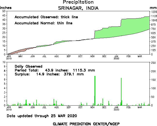
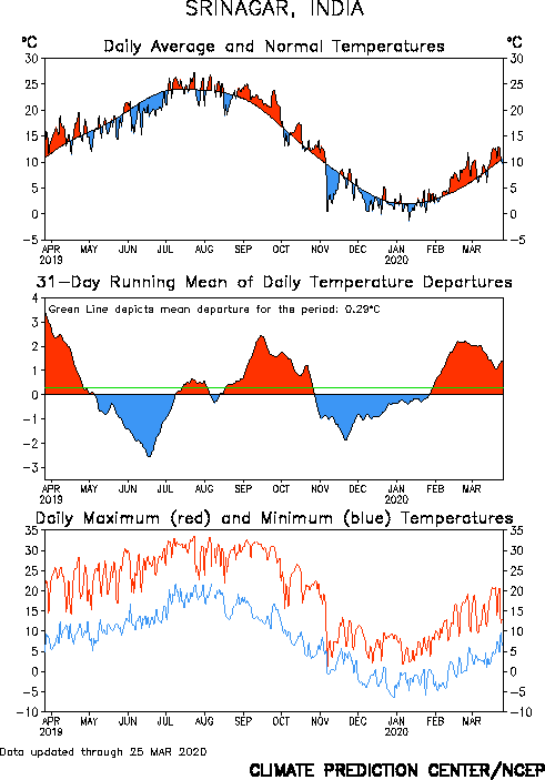
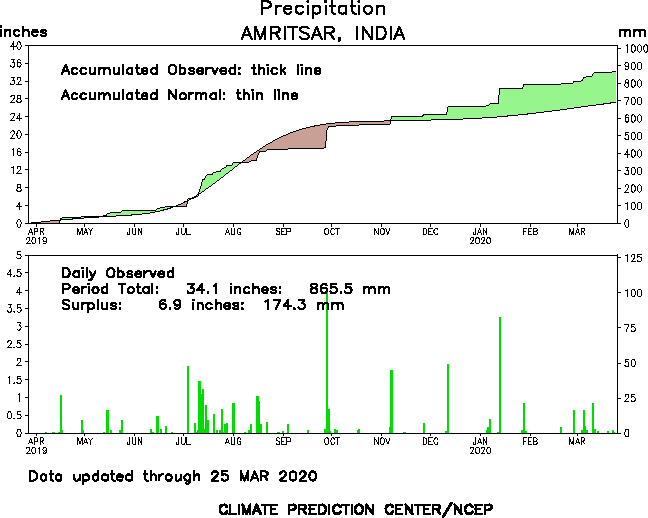
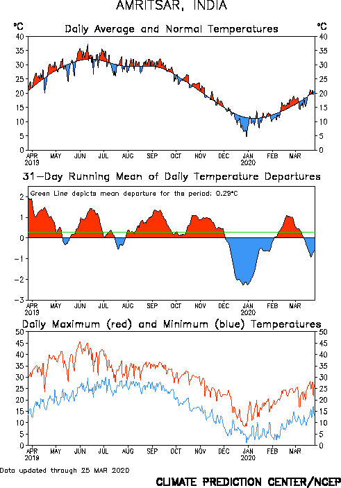
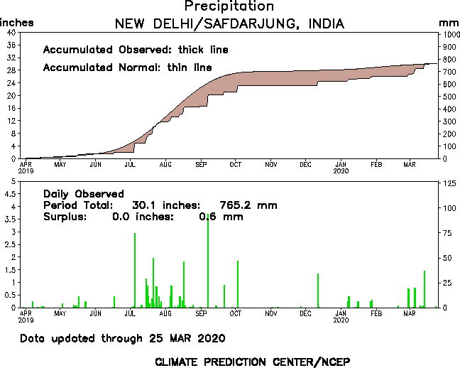
1) North India-
Srinagar -
PPT- NRM ( EX in April,DF in June)
TEMP-HIGH (LOW in April)
Amritsar-
PPT- DEF
TEMP-HIGH
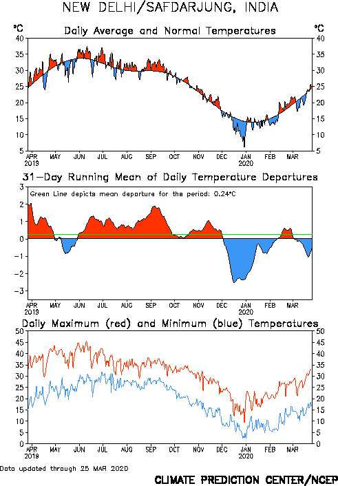
* New Delhi
PPT-NRM
TEMP-HIGH
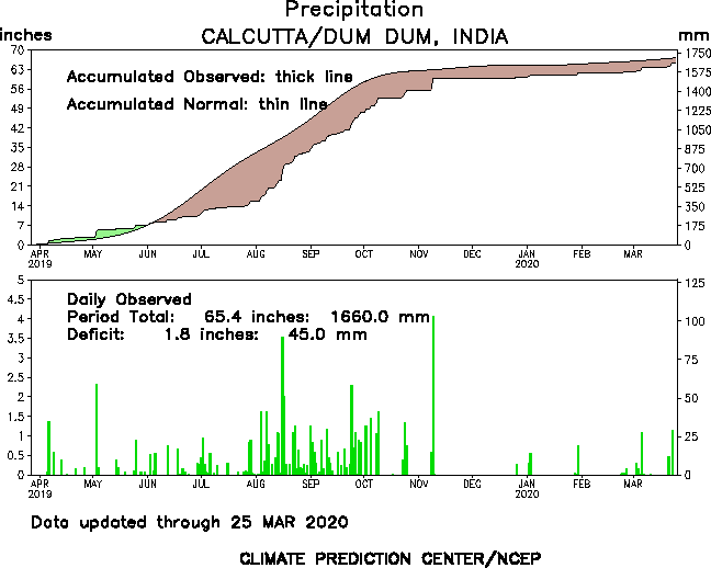
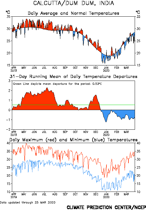
2) East India-
* Kolkata
PPT-EX
TEMP- LOW
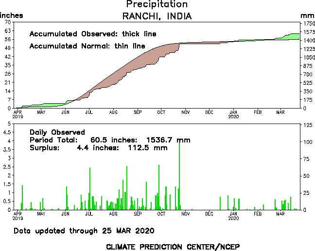
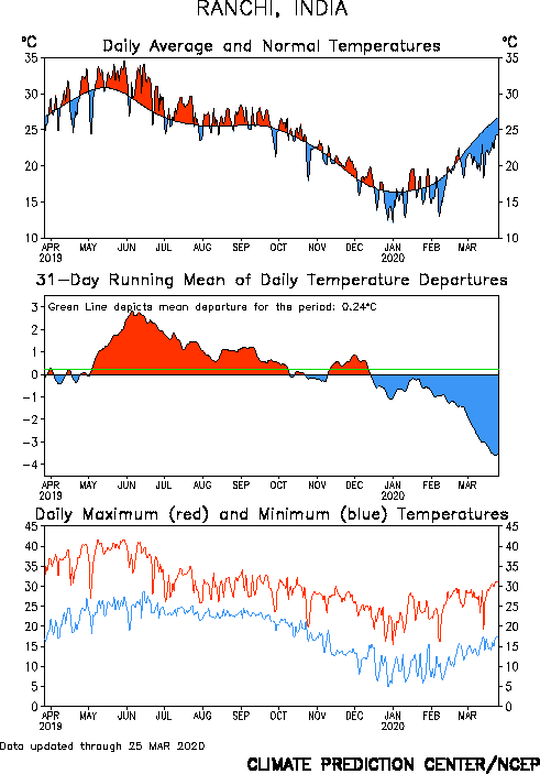
Ranchi
TEMP- LOW
PPT- NRM
* Bhubaneshwar
Temp-HIGH
PPT-NRM
3) Central India
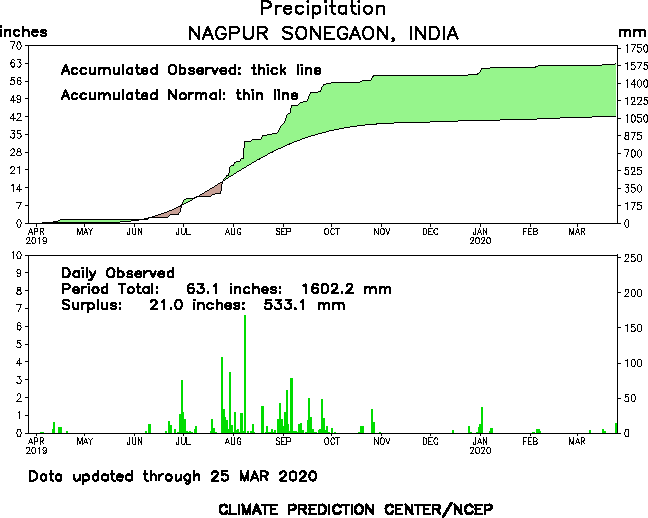
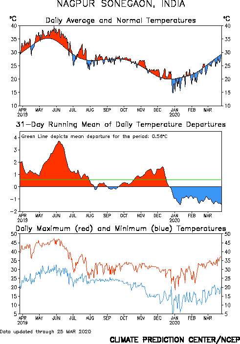
Nagpur-
TEMP- LOW
PPT-EX
*Pendra-
TEMP-LOW
PPT-EX
*Jharsuguda-
TEMP-LOW
PPT-NRM
4) Southern India
*Chennai
TEMP- LOW
PPT-EX
*Trivandrum-
TEMP-HIGH
PPT-NRM
*Anantapur-
TEMP-LOW
PPT-EX
5) Western India
*Mumbai (Santacruz)-
TEMP- HIGH
PPT-NA
*Ahmedabad-
TEMP-HIGH
PPT-NA
*GOA-
TEMP-HIGH
PPT-NRM
6) North-East India
*Agartala
TEMP- HIGH
PPT-DEF
*Guwahati-
TEMP-HIGH
PPT-DEF
*TEZPUR-
TEMP-HIGH
PPT-EX
7) NCR group
*Gwalior-
TEMP-HIGH
PPT-NRM
*Allahabad-
TEMP-HIGH
PPT-NRM
*Lucknow-
TEMP-LOW
PPT-EX
8) Desert Region
*Bhuj-
TEMP-LOW
PPT-NRM
*Bikaner-
TEMP-HIGH
PPT-NRM
The graphics were not posted due to exceeding length of this article. It can be found in the link in the reference.
-------------------------------------------------------------------------------------------------------------------------------------
4. RELATION (CONCLUSION) WITH CHAPTER 2.
STATISTICS-
TOTAL STATIONS- 23
STATIONS REPORTED MORE THAN NORMAL TEMP- 14 ( NORTHERN AND WESTERN INDIA MOSTLY AND THE ENTIRE NORTH-EAST )
STATIONS REPORTING COOLER THAN NORMAL- 9 ( CENTRAL INDIA AND EASTERN INDIA AND SOUTHERN INDIA PROMINENTLY)
STATIONS REPORTING NORMAL RAINFALL - 11
STATIONS REPORTING MORE THAN NORMAL RAINFALL- 7
STATIONS REPORTING LESS THAN NORMAL RAINFALL - 3
NO DATA- 2
INFERENCE-
The overall data suggests that a Moderate La Nina allows Central India,Eastern India and Southern India to cool more than Northern and Western India. The Positive IOD helps in maintaing the rainfall amounts and provides excess in some areas particularly in South India.

-------------------
All this satisfies the JAMSTEC Surface air temperature forecast for 2011 Summer
------------------------------------------------------------------------------------------------------------------
5. 2012 Expected Parameters of ENSO,IOD,MJO
The ENSO is going to behave all together this year! Finally there are signs of weakening of the persisting La Nina in the Nino 3.4 region. We shall see the present ( Mid March 2012) situation of the Pacific Ocean
The following are the observed anomalies in the Equatorial Pacific region in this week!
NINO 4: -0.8C
NINO3.4: -0.6C
NINO 3: -0.2C
NINO 1+2: 0.4C


Transition to Neutral Conditions VERY LIKELY

The above SST anomaly plot of March 11 2012 shows some warming areas offshore Western South America (denoted as yellow green region with symbol H 2.63). Also a significant warming is seen offshore Eastern South America,across East Asia,Australia. This is a textbook feature that transition process has initiated or decaying of La Nina has started as the trade winds would be relaxing a bit. However there has not been any confirmed deviation from the trade wind across the region which will turn up soon!
The formation of higher SST across South America's Western coast often marks the transitioning to Neutral and even further to El Nino. For instance see this

The above is a SST anomaly of 7th Feb 2009 ( during a weak La Nina as seen in the NINO regions). There was a weak La Nina going on during this period which rapidly transformed into El Nino from Summer of 2009.

However a similar analysis (SST anomaly) of 5th Feb 2012 reveals a bit deeper cooling and much more Neg anomaly regions.
As a result of the clear difference from the two images,
the final conclusion that arrives is that there is a very high chance of La Nina transforming into Neutral state of ENSO during LATE APRIL period. So the 2012 Summer will have a weak La Nina till May begininning and then Neutral ENSO from May onwards.
Possible El Nino from late monsoon period and Winter of 2012.
The Indian Ocean Dipole is expected to be positive for the summer period.
The Madden Jullian Oscillation activity will be dropping to positive or suppressed convection from late summer period due to ENSO transitions.
-------------------------------------------------------------------------------------------------------------------------------------
6. 2012 SUMMER FORECAST FOR INDIA

After reviewing all the basic parameters, it appears that the Summer will get to see MIXED EFFECTS due to ongoing weak La Nina and the transition period. The Weak La Nina will cool down Central India,Southern India and Eastern India prominently by around -0.1C to -0.5C on average.
Subsequently the Northern India will be warming up again this Summer by around +0.1C to +0.5C on an average. In the month of May,temperature variations can take place where most of the places will mark the highest of the season temperature
The overall precipitation activity seems to be FAIR with most of the stations reporting NORMAL RAINFALL DURING THE PERIOD
Zonal Wise Forecast.
Note- The scales are as compared to average i.e (+0.1C) when counted on the average
North India,NCR,Desert Region -
Warmer than normal summer. The overall temperature records shall be similar to 2011 year with temperature variation of ( +0.1 to +0.5 C)
East India-
The areas of Eastern India will witness a COOLER than normal Summer. The Temperature anomaly will be around ( -0.4C to -0.7C). The precipitation levels shall match the normal level
Southern India-
Continuing the tradition, Southern India also will witness Cooler Summer. However many areas will be experiencing normal summer. These areas are difficult to point out in general
Temperature variation shall be 0C to -0.2C
Western India-
Western India will be warming up this year with temperature variation expected around (+0.1C to +0.3C).Anticyclones at lower levels in the Arabian Sea and over Gujarat would play a decisive role.
Central India-
Central India will also COOL this year. However the strength of this cooling shall be LOWER than experienced previous year which will be pushing most of the stations to a NORMAL or JUSTBELOW NORMAL LEVEL
Temperature variation shall be around (-0.1C to -0.3C).
North-Eastern States-
The North-Eastern States will experience a cooling pattern this year due to assisted neutral ENSO.
Temperature variations shall reach from -0.3C to -0.7C.
NAGPUR WEATHER-
THE HIGHEST TEMPERATURE WHICH MAY HIT NAGPUR THIS YEAR WILL BETWEEN 45.5C (+ OR MINUS 0.5C).
THE TEMPERATURE SHALL BE REACHING IN MAY 2012. IN ALL THERE WILL BE NOT MORE THAN 3-4 RAINFALL EVENTS DURING MAY
-------------------------------------------------------------------------------------------------------------------------------------
7 REFERENCES-
CLIMATE PREDICTION CENTER- FOR MJO,ENSO PARAMETERS AND WEATHER STATIONS DATA (GRAPHS)
http://www.cpc.ncep.noaa.gov/products/precip/CWlink/MJO/enso.shtml
http://www.cpc.ncep.noaa.gov/products/analysis_monitoring/lanina/enso_evolution-status-fcsts-web.pdf
http://www.cpc.ncep.noaa.gov/products/precip/CWlink/daily_mjo_index/mjo_index.shtml (MJO)
http://www.cpc.ncep.noaa.gov/products/analysis_monitoring/regional_monitoring/asia.shtml
JAMSTEC- FOR INDIAN OCEAN DIPOLE AND SURFACE AIR TEMP PLOT
http://www.jamstec.go.jp/frsgc/research/d1/iod/sintex_f1_forecast.html.en
UNISYS WEATHER- FOR SEA SURFACE TEMP ANOMALY
http://weather.unisys.com/archive/sst/
INTERNATIONAL RESEARCH INSTITUTE FOR CLIMATE AND SOCIETY ( ENSO FORECAST)
http://iri.columbia.edu/climate/ENSO/currentinfo/archive/201203/figure3.html
GOLDEN GATE WEATHER SERVICE AND CPC FOR SST HISTORICAL DATA
http://ggweather.com/enso/oni.htm
BUREAU OF METEOROLOGY,AUSTRALIA FOR PROVIDING SOI INDICES
http://www.bom.gov.au/climate/current/soihtm1.shtml
-------------------------------------------------------------------------------------------------------------------------------------
AKSHAY DEORAS
SEVERE WEATHER FORECASTER
METD WEATHER is presenting the 2012 Summer Forecast for India. The Summer Forecast of this year has two sections. In the first section,we have compared the overall dynamics of the country during April-May-June period of 2011. A comparison also has been made with the overall modes of ENSO,IOD,MJO last year with the temperature anomaly observed. The source of the data ( links at reference) ( Temperature anomaly) is National Weather Service Climate Prediction Center ,NOAA PMEL (ENSO and SST anomalies) and Climate Prediction Center Madden Jullian Oscillation.
2012 Forecast for this year is going to be a specified one that is forecast for specific areas unlike the previous year's general forecast for regions. We will be considering a total of 8 segments of India which will include-
1) North India
2) East India
3) Central India
4) Southern India
5) Western India
6) North-Eastern India
7) NCR region (vicinity of New Delhi)
8) Rajasthan,Gujarat (desert area)
Below are the stations ( cities) whose 2011 dynamics have been considered and forecast of 2012 will be issued for them
1) North India-
Srinagar,Amritsar,New Delhi
2) East India
Kolkata,Ranchi,Bhubaneshwar
3) Central India
Nagpur,Pendra,Jharsuguda
4) Southern India
Chennai,Trivandrum,Anantpur
5) Western India
Mumbai (Santacruz),Ahmedabad,Goa
6) North-East India
Agartala,Guwahati,Tezpur
7) NCR group
Gwalior,Allahabad,Lucknow
8) Desert Region
Bhuj,Bikaner
~ A.Deoras
-------------------------------------------------------------------------------------------------------------------------------------
CHAPTERS-
1) INTRODUCTION TO THE SUMMER SEASON OF INDIA
2) STATES OF ENSO,IOD,MJO DURING SUMMER 2011
3) DIVISION WISE COMPARISON OF TEMPERATURE,PRECIPITATION ANOMALY DURING SUMMER 2011
4) RELATION (CONCLUSION) WITH CHAPTER 2.
5) 2012 EXPECTED PARAMETERS OF ENSO,IOD,MJO
6) 2012 SUMMER FORECAST
7) REFERENCES
-------------------------------------------------------------------------------------------------------------------------------------
I. Introduction to the summer season of India
The Summer Season mostly begins in March and entends till June for most of the areas of India. The apparent migration of the Sun in the Northern hemisphere permits more and more heat to enter the Indian subcontinent which causes a significant rise of temperature both maximum and minimum. The prominent feature of Summer for most of the areas are dry westerly winds which boost dry air to come from the gulf areas which increase the overall temperature for Central India. Many times a high pressure or anticyclone is observed over Gujarat at 850mb levels which leads to strong anomalies (positive) in the temperatures over Western India.
The overall climate for this tenure in the country is dry with westerly winds. During this period, sandstorms are a bit common for North India plains.
The overall summer activity decides the state of the Summer Monsoon which follows the summer after some period. Most of the areas also witness convective activity with thunderstorms flaring due to enhanced heat available for convection.
It has been widely observed that there is a strong variation in the Indian summer which directly has a relation with the ENSO or the El Nino Southern Oscillation.Factors like MJO,IOD are of secondary importance for Summer Forecast
-------------------------------------------------------------------------------------------------------------------------------------
2.STATES OF ENSO,IOD,MJO DURING SUMMER 2011
We consider the states of ENSO,IOD,MJO during a period (FMA,MAM,AMJ)
I- ENSO
After a strong La Nina event of 2010, the SST of Equatorial Pacific showed declining event in the Summer of 2011 where a Weak La Nina was in place. The SST anomaly in the Nino 3.4 region was
-1.0 during Feb-March-April (MDT La Nina)
-0.7 during March-April-May (Weak La Nina)
-0.4 during April-May-June ( Weak La Nina)
 |
| 06th Feb 2011 SST anomaly plot shows the STRONG La Nina in Nino 3.4 region. |
 |
| 20th March 2011 SST Anomaly shows the La Nina in progress in the Nino 3.4 region prominently. |
 |
| May 2011 analysis shows further weakening of La Nina. |
 |
| The Oceanic Nino Index ( ONI) showing the overall IOD states. For 2011 see extreme right of the image. |
IOD-
The overall phase of IOD was positive
During a strong ENSO event, there are observed strong variations in the Indian summer i.e cooler than normal summer for most of the areas during La Nina and warmer than normal summer during El Nino. It has also been observed that there is a periodic pattern observed in the anomaly of Surface Air Temperature in a direct relation with ENSO.
There doesn't appear a direct relation of Madden Jullian Oscillation with the Summer as it does with the Monsoon of India. The most of the precipitation activity is convective based and hence not related to MJO. The Indian Ocean Dipole ( IOD) plays an important role in overall precipitation during Summer period.A Positive event tends to bring more rainfall in India. We shall consider the Precipitation anomaly of 2011 Summer period below in Chapter 3.
The MJO activity is minimum during Summer and hence not a major influence is shown by MJO as it does for Monsoon. We shall neglect this parameter..
-------------------------------------------------------------------------------------------------------------------------------------
3. DIVISION WISE COMPARISON OF TEMPERATURE,PRECIPITATION ANOMALY DURING SUMMER 2011
We consider the Zonal Precipitation Anomalies of 2011 during Summer period and try to establish a relation with IOD. The data will be mentioned in the format- Normal( NRM),Excess ( EX) and Deficient ( DF).
We also consider Temperature anomaly during the same period. More than normal (HIGH),Normal ( NRM),less than normal ( LOW),PPT ( Precipitation),Temperature ( TEMP)
1) North India-
Srinagar -
PPT- NRM ( EX in April,DF in June)
TEMP-HIGH (LOW in April)
Amritsar-
PPT- DEF
TEMP-HIGH
* New Delhi
PPT-NRM
TEMP-HIGH
2) East India-
* Kolkata
PPT-EX
TEMP- LOW
Ranchi
TEMP- LOW
PPT- NRM
* Bhubaneshwar
Temp-HIGH
PPT-NRM
3) Central India
Nagpur-
TEMP- LOW
PPT-EX
*Pendra-
TEMP-LOW
PPT-EX
*Jharsuguda-
TEMP-LOW
PPT-NRM
4) Southern India
*Chennai
TEMP- LOW
PPT-EX
*Trivandrum-
TEMP-HIGH
PPT-NRM
*Anantapur-
TEMP-LOW
PPT-EX
5) Western India
*Mumbai (Santacruz)-
TEMP- HIGH
PPT-NA
*Ahmedabad-
TEMP-HIGH
PPT-NA
*GOA-
TEMP-HIGH
PPT-NRM
6) North-East India
*Agartala
TEMP- HIGH
PPT-DEF
*Guwahati-
TEMP-HIGH
PPT-DEF
*TEZPUR-
TEMP-HIGH
PPT-EX
7) NCR group
*Gwalior-
TEMP-HIGH
PPT-NRM
*Allahabad-
TEMP-HIGH
PPT-NRM
*Lucknow-
TEMP-LOW
PPT-EX
8) Desert Region
*Bhuj-
TEMP-LOW
PPT-NRM
*Bikaner-
TEMP-HIGH
PPT-NRM
The graphics were not posted due to exceeding length of this article. It can be found in the link in the reference.
-------------------------------------------------------------------------------------------------------------------------------------
4. RELATION (CONCLUSION) WITH CHAPTER 2.
STATISTICS-
TOTAL STATIONS- 23
STATIONS REPORTED MORE THAN NORMAL TEMP- 14 ( NORTHERN AND WESTERN INDIA MOSTLY AND THE ENTIRE NORTH-EAST )
STATIONS REPORTING COOLER THAN NORMAL- 9 ( CENTRAL INDIA AND EASTERN INDIA AND SOUTHERN INDIA PROMINENTLY)
STATIONS REPORTING NORMAL RAINFALL - 11
STATIONS REPORTING MORE THAN NORMAL RAINFALL- 7
STATIONS REPORTING LESS THAN NORMAL RAINFALL - 3
NO DATA- 2
INFERENCE-
The overall data suggests that a Moderate La Nina allows Central India,Eastern India and Southern India to cool more than Northern and Western India. The Positive IOD helps in maintaing the rainfall amounts and provides excess in some areas particularly in South India.
-------------------
All this satisfies the JAMSTEC Surface air temperature forecast for 2011 Summer
------------------------------------------------------------------------------------------------------------------
5. 2012 Expected Parameters of ENSO,IOD,MJO
The ENSO is going to behave all together this year! Finally there are signs of weakening of the persisting La Nina in the Nino 3.4 region. We shall see the present ( Mid March 2012) situation of the Pacific Ocean
The following are the observed anomalies in the Equatorial Pacific region in this week!
NINO 4: -0.8C
NINO3.4: -0.6C
NINO 3: -0.2C
NINO 1+2: 0.4C

The SST Anomalies mentioned in the respective regions is given in a graphical format below
Transition to Neutral Conditions VERY LIKELY
The above SST anomaly plot of March 11 2012 shows some warming areas offshore Western South America (denoted as yellow green region with symbol H 2.63). Also a significant warming is seen offshore Eastern South America,across East Asia,Australia. This is a textbook feature that transition process has initiated or decaying of La Nina has started as the trade winds would be relaxing a bit. However there has not been any confirmed deviation from the trade wind across the region which will turn up soon!
The formation of higher SST across South America's Western coast often marks the transitioning to Neutral and even further to El Nino. For instance see this
The above is a SST anomaly of 7th Feb 2009 ( during a weak La Nina as seen in the NINO regions). There was a weak La Nina going on during this period which rapidly transformed into El Nino from Summer of 2009.
However a similar analysis (SST anomaly) of 5th Feb 2012 reveals a bit deeper cooling and much more Neg anomaly regions.
As a result of the clear difference from the two images,
the final conclusion that arrives is that there is a very high chance of La Nina transforming into Neutral state of ENSO during LATE APRIL period. So the 2012 Summer will have a weak La Nina till May begininning and then Neutral ENSO from May onwards.
Possible El Nino from late monsoon period and Winter of 2012.
The Indian Ocean Dipole is expected to be positive for the summer period.
The Madden Jullian Oscillation activity will be dropping to positive or suppressed convection from late summer period due to ENSO transitions.
-------------------------------------------------------------------------------------------------------------------------------------
6. 2012 SUMMER FORECAST FOR INDIA

 |
| The above plot is generated by JAMSTEC. Courtesy- JAMSTEC |
After reviewing all the basic parameters, it appears that the Summer will get to see MIXED EFFECTS due to ongoing weak La Nina and the transition period. The Weak La Nina will cool down Central India,Southern India and Eastern India prominently by around -0.1C to -0.5C on average.
Subsequently the Northern India will be warming up again this Summer by around +0.1C to +0.5C on an average. In the month of May,temperature variations can take place where most of the places will mark the highest of the season temperature
The overall precipitation activity seems to be FAIR with most of the stations reporting NORMAL RAINFALL DURING THE PERIOD
Zonal Wise Forecast.
Note- The scales are as compared to average i.e (+0.1C) when counted on the average
North India,NCR,Desert Region -
Warmer than normal summer. The overall temperature records shall be similar to 2011 year with temperature variation of ( +0.1 to +0.5 C)
East India-
The areas of Eastern India will witness a COOLER than normal Summer. The Temperature anomaly will be around ( -0.4C to -0.7C). The precipitation levels shall match the normal level
Southern India-
Continuing the tradition, Southern India also will witness Cooler Summer. However many areas will be experiencing normal summer. These areas are difficult to point out in general
Temperature variation shall be 0C to -0.2C
Western India-
Western India will be warming up this year with temperature variation expected around (+0.1C to +0.3C).Anticyclones at lower levels in the Arabian Sea and over Gujarat would play a decisive role.
Central India-
Central India will also COOL this year. However the strength of this cooling shall be LOWER than experienced previous year which will be pushing most of the stations to a NORMAL or JUSTBELOW NORMAL LEVEL
Temperature variation shall be around (-0.1C to -0.3C).
North-Eastern States-
The North-Eastern States will experience a cooling pattern this year due to assisted neutral ENSO.
Temperature variations shall reach from -0.3C to -0.7C.
NAGPUR WEATHER-
THE HIGHEST TEMPERATURE WHICH MAY HIT NAGPUR THIS YEAR WILL BETWEEN 45.5C (+ OR MINUS 0.5C).
THE TEMPERATURE SHALL BE REACHING IN MAY 2012. IN ALL THERE WILL BE NOT MORE THAN 3-4 RAINFALL EVENTS DURING MAY
-------------------------------------------------------------------------------------------------------------------------------------
7 REFERENCES-
CLIMATE PREDICTION CENTER- FOR MJO,ENSO PARAMETERS AND WEATHER STATIONS DATA (GRAPHS)
http://www.cpc.ncep.noaa.gov/products/precip/CWlink/MJO/enso.shtml
http://www.cpc.ncep.noaa.gov/products/analysis_monitoring/lanina/enso_evolution-status-fcsts-web.pdf
http://www.cpc.ncep.noaa.gov/products/precip/CWlink/daily_mjo_index/mjo_index.shtml (MJO)
http://www.cpc.ncep.noaa.gov/products/analysis_monitoring/regional_monitoring/asia.shtml
JAMSTEC- FOR INDIAN OCEAN DIPOLE AND SURFACE AIR TEMP PLOT
http://www.jamstec.go.jp/frsgc/research/d1/iod/sintex_f1_forecast.html.en
UNISYS WEATHER- FOR SEA SURFACE TEMP ANOMALY
http://weather.unisys.com/archive/sst/
INTERNATIONAL RESEARCH INSTITUTE FOR CLIMATE AND SOCIETY ( ENSO FORECAST)
http://iri.columbia.edu/climate/ENSO/currentinfo/archive/201203/figure3.html
GOLDEN GATE WEATHER SERVICE AND CPC FOR SST HISTORICAL DATA
http://ggweather.com/enso/oni.htm
BUREAU OF METEOROLOGY,AUSTRALIA FOR PROVIDING SOI INDICES
http://www.bom.gov.au/climate/current/soihtm1.shtml
-------------------------------------------------------------------------------------------------------------------------------------
No comments:
Post a Comment